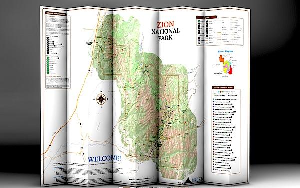
Day Hikes Of Zion National Park folds into a nice, waterproof, portable guide to Zion's day hikes/hike734
You're planning a trip to Zion National Park in Utah, you plan to do some hiking, and you're wondering which trails to search out.
You could pick up a copy of 50 Best Short Hikes In Utah's National Parks, which would be a good start in identifying some hikes in Zion. But a new "map guide" from Jake Bramante, the guy who hiked all 734 miles of Glacier National Park in one year, would be a good investment, too, if you're solely interested in day hiking in the park.
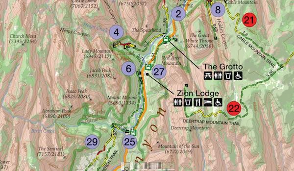
Day Hikes of Zion National Park, which provides details on 29 hikes in the park, is printed on tear-resistant, waterproof paper that folds down to a roughly 4.5-inch by 9-inch brochure that you can stuff in your back pocket or day pack. Unfold it and you find a map of the park with key facilities (restrooms, visitor center, lodging, picnic areas, etc) marked along with numbered hikes. Shuttle bus stops in the park as well as neighboring Springdale also are numbered to help you catch a ride.
This map is similar to Bramante's Day Hikes Of Glacier National Park. Hikes in the Zion guide are color-coded by region in the park. So if you look at all the purple-coded hikes, you'll know they're in the same general area of the park; in this case, in Zion Canyon. Green circles denote trails on the West Rim, violet is tagged to those on North Creek, yellow indicates southwest desert, light blue is The Narrows, and red is Kolob Canyons and the East Rim. Lines denoting the trails are even color coded: green for easy, yellow for moderate, and red for strenuous.
The map color codes hikes by region, and uses more colors to denote easy, moderate, and strenuous hikes/hike734
A glance at "Jake's Order of Hikes, which lists his favorites in descending order, tells you whether you'll encounter steep cliffs, whether a particular hike is family friendly, and whether the trail is accessible.
On the back of the map you'll find a breakdown of the trails with descriptions. Here Bramante segregated the hikes by distance, so you can quickly identify the mileage so you don't overdo it. You'll also find a box of safety information, ranging from steep cliffs in the park to the need to drink lots of water in this desert setting and even symptoms of heat stroke.
There's even a small box of information on where you can obtain additional books and maps.
If day hiking is your goal, this is a good tool to help you plan, and pull off, your day-long journeys in Zion. You can order a copy at Mr. Bramante's website.


Comments
EC--
What I was trying to communicate is that it probably _isn't_ a NPS policy decision, and that I know of no NPS policy on providing GPS coordinates to the public. Rather, the park-level folks who would do this don't know that it is more of a priority to visitors than other things they're working on when they're not at the visitor center front desk. A few polite requests, with a use-case of why it would be helpful to you so that the ranger can explain or sell the request to their supervisors, are likely to do the trick. The key is that this will have to be done park by park, as local park folks need to check the data to make sure it is current and valid and safe (for instance, I know that Death Valley has some things in their "roads" GIS coverage that aren't roads that would be a serious safety issue if included in GPX files).
Then I would suggest someone(s) has made that decision. It may not be a written policy but it is what gets implimented.
Interesting. Just book a backcountry trip in RMNP. Asked about .gpx files on the campsites. The ranger said yes they have them and he would email them to me.
So indeed they exist. It would be nice to have them posted on the websites.
ec, it would be possible to come up with quite a list of items individual visitors might like for a park staff to provide, but the fact those items or pieces of information aren't already available doesn't mean a policy has been issued to prohibit their production or release.
You may disagree, but in my opinion the majority of NPS staffers who have the technical expertise to provide what you want here already have more than enough on their plates. As others have explained above, until there are enough requests to move this up on somebody's "to-do" list, it probably won't happen anytime soon.
And, some perspective is in order here from an admittedly old school hiker. Availability of GPS coordinates for backcountry sites is in the "nice to have" category. It would be useful for some visitors, but it's hardly critical for a safe trip, and as one comment above points out, unless it's up to date and verified, such info can lead some visitors astray or even into dangerous situations.
I was working on my comment above while you posted another one. See, no policy against such info. Sometimes, all you have to do is ask, and after several such requests, it's more likely to get posted somewhere.
So I guess that dispells all the earlier excuses. Its basic info and easily integrated into the websites. It would be nice to have.
Thank you Jim, I agree, I am not sure it is a responsibility of the public land agencies to post or allow for every "nice to have" piece of information. I was also delighted to see a comment on the importance of "Art in the Parks", "Artist in Residence Programs", etc and the extremely significant contributions these persons have made to our enjoyment and support of Parks and Wild Lands. Must include the Traveler website in the continuing effort.
"
and other efforts to continue the contributions made by writers, photgraphers, artists, etc.
Sorry Ron, I find backcountry campsites much closer to the Parks mission than some performing artist. And when a "nice to have" takes virtually no addional effort or monies I see little reason not to provide it. Are you suggesting we eliminate every interpretive sign, ranger program or park exhibit because they are only "nice to have"?
Man, someone makes a suggestion to improve the backcountry experience and NPS websites (two subjects already brought up here before) and you NPS defenders get your back hairs up in a jiffy. I'm not a NPS basher. All in all I think they do a very good job. That doesn't mean they can't be open to some suggestions. They probably are but seems like an awful lot of people here aren't.