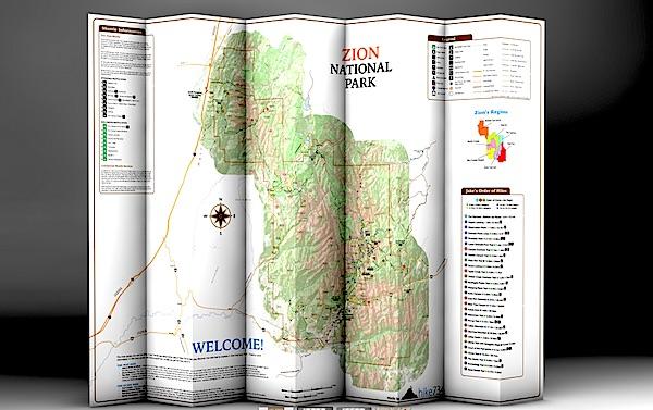
Day Hikes Of Zion National Park folds into a nice, waterproof, portable guide to Zion's day hikes/hike734
You're planning a trip to Zion National Park in Utah, you plan to do some hiking, and you're wondering which trails to search out.
You could pick up a copy of 50 Best Short Hikes In Utah's National Parks, which would be a good start in identifying some hikes in Zion. But a new "map guide" from Jake Bramante, the guy who hiked all 734 miles of Glacier National Park in one year, would be a good investment, too, if you're solely interested in day hiking in the park.
Day Hikes of Zion National Park, which provides details on 29 hikes in the park, is printed on tear-resistant, waterproof paper that folds down to a roughly 4.5-inch by 9-inch brochure that you can stuff in your back pocket or day pack. Unfold it and you find a map of the park with key facilities (restrooms, visitor center, lodging, picnic areas, etc) marked along with numbered hikes. Shuttle bus stops in the park as well as neighboring Springdale also are numbered to help you catch a ride.
This map is similar to Bramante's Day Hikes Of Glacier National Park. Hikes in the Zion guide are color-coded by region in the park. So if you look at all the purple-coded hikes, you'll know they're in the same general area of the park; in this case, in Zion Canyon. Green circles denote trails on the West Rim, violet is tagged to those on North Creek, yellow indicates southwest desert, light blue is The Narrows, and red is Kolob Canyons and the East Rim. Lines denoting the trails are even color coded: green for easy, yellow for moderate, and red for strenuous.
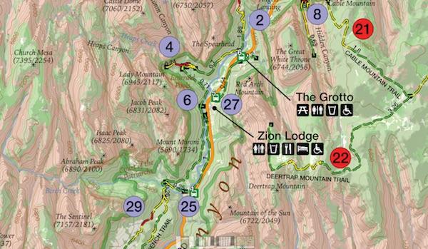
The map color codes hikes by region, and uses more colors to denote easy, moderate, and strenuous hikes/hike734
A glance at "Jake's Order of Hikes, which lists his favorites in descending order, tells you whether you'll encounter steep cliffs, whether a particular hike is family friendly, and whether the trail is accessible.
On the back of the map you'll find a breakdown of the trails with descriptions. Here Bramante segregated the hikes by distance, so you can quickly identify the mileage so you don't overdo it. You'll also find a box of safety information, ranging from steep cliffs in the park to the need to drink lots of water in this desert setting and even symptoms of heat stroke.
There's even a small box of information on where you can obtain additional books and maps.
If day hiking is your goal, this is a good tool to help you plan, and pull off, your day-long journeys in Zion. You can order a copy at Mr. Bramante's website.


Comments
Add it to the maintenance backlog.
Google Earth does have all the coordinates. All one has to do is place the cursor over the campsite or trail junction or whatever you are looking for and PRESTO, there it is.
I just used G E to plot my hiking plans for a trip into Grand Staircase. It took all of maybe fifteen minutes and in the process, I discovered some interesting things I hadn't known about before. In addition to G E, there are a large number of online and CD disk sets of state topo maps. My Utah topos are from National Geographic. They work even better for some things than G E.
Wanting the government to do it for us without wanting to pay for it is a perfect example of the hypocrisy of the Tea Party Entitlement Mentality.
Now lets leave it up to other readers to make their own decisions here.
But those campsites aren't marked on G E.
Who said I wouldn't pay? Wouldn't my entrance fee be paying for this? Wouldn't the backcountry permit be paying for this? Wouldn't my taxes be paying for this. Heck, I find this a far more usefull and mission relevant expenditure than say the "artist in residence" program. The cost of creating this database is miniscule. Such GPX files are available, for free, for many other hikes. I downloaded one showing every Shelter on the AT. Another the plot of the entire Colorado Trail. As I said before, I would think this info would be valuable to the Park itself. In fact, I would be surprised if they don't already have the information. Or if they asked for it, hikers would give it to them for free.
http://www.everytrail.com/best/hiking-zion-national-park
Excellent resource for trails, waypoints, photos, and gps files.
Thank you dahkota. That looks like one more fine resource. I've bookmarked it and will be checking it more thoroughly.
Duplicate post; my apologies.
I tried to finish my response while running a big slow data fetch from home.
I've had to change this response 3 times now as other posts come in faster than I can get to this reply.
1: Getting the coordinates for campgrounds, trails, etc., does not involve rangers or even volunteers marching around with GPS units. By now all parks should have roads, trails, and all facilities and named locations as GIS data: "Base Cartography" was one of the 12 core inventories for the ~280 units with natural resources. [We use polylines of trails to design sampling schemes for monitoring new invasive weeds, to compute travel times for monitoring crews and for SAR.] Technically, the process would take a bit of review for closed or re-routed trails and campsites (data get outdated), then not much more than a GIS tech using the ArcGIS Data Interoperability Extension to dump the data in GPX format usable by most brands of consumer GPS units, dropping all attributes except the trail or site name. [2 potential issues: I suspect that the GPX files are a format our webserver blocks, so users would download a .txt file and have to rename it; folks selling apps or downloadable GPX files can potentially prevent NPS from competing with them.]
2: I think that a very few folks requesting coordinates for trail junctions, campgrounds, trails, etc., especially with 1 or 2 sentence use-cases for the trail as polylines in their requests, would be enough to get this done at most parks. I suspect that the issue is more that rangers & natural resource folks don't tend to use GPS units this way, so they don't understand why these coordinates would be useful to you. Many natural resource folks, data managers, and even some interp rangers can use ArcGIS. Make the request to individual parks; if they can't do it themselves they can ask their I&M network for support.
3: I don't know about any current NPS policy about providing GPS coordinates, liability, etc. . My understanding from long before I joined NPS is that there used to be substantial liability issues with providing sets of GPS coordinates: folks would plug them into their GPS in the wrong CRS (NAD27 instead of NAD83/WGS84) and blame the coordinate provider, or use them to attempt cross-country travel and end up an impassable cliffs and blame the coordinate provider, etc.. Many organizations & agencies with less than expert audiences quickly stopped providing coordinates. While I hope more GPS users now know what they're doing, modern handhelds are more idiot-proof, and GPX specifies WGS84 decimal degrees, to some extent providing GPS coordinates still promotes off-trail cross-country use. That can lead to folks coming to cliffs, dangerous stream crossings, etc., so I can see that neither SAR nor resource protection folks would make providing GPS coordinates to the general public a high priority (that doesn't mean that they would _oppose_ providing coordinates). Again, that is my personal impression and (non-NPS) experience, not NPS policy.
4: As several folks have noted, you can get your coordinates from google earth if you can recognize it from the aerial photography. If I were doing lots of points or tracing a trail or stream, I would use the push-pins for places and paths for trails, then right-click on the tree of points and save as kml; then use something like GPSBabel to convert that kml to GPX to upload to my GPS unit.
Tomp2 - Your post sounds like it is coming from someone with some knowledge of the issue. Points 1 & 2 confirm my belief that the coordinates and/or resources to create them already exist.
Point three also is in line with my suspicions that not providing the coordinates is more a policy decision than anything else. I don't agree with the decision and think the "liability" issue is stupid, though in these litigious days, the PC correct thing to do. I don't see how there is any more liability in GPS coordinates than in those rough hand sketched maps they pass out. Its about time the rest of us stopped being penalized for the stupidity of a few.
On point 4) for trails I use Topo USA. Put a start pin at the start and a finish pin at the end and then one click createa a route. One more click and you have a direct download to the GPS from there. Campsites are another matter as they generally aren't shown in standard Topo sofware, are frequently invisable on Google Earth and are only approximated on such maps as Nat Geo where interpelation is needed to even get to the "approximate" location. GPS downloads from the National Park "Service" would be a nice "service" commenserate with (and cheaper than) interpretive signs, ranger presentations and park museums. But then I guess interpretive signs, ranger presentations and park museums are just Tea Pary entitlement mentality.