In the late 1940s, Marjory Stoneman Douglas poetically labeled the Everglades a “River of Grass” in her renowned book. This brings up an interesting question: Is the River of Grass a river or just a poetic name? Native Americans originally called the Everglades “Pa-hay-Okee,” meaning “grassy waters,” while early European explorers crafted the region’s name from the words “forever” and “glades” (a grassy open place). Who was right? Will the real Everglades — a river, wetland, or some watery space in between — please step forward?
A plethora of river classifications exist, but in its most basic form, a river is a natural stream of water flowing in a channel to a lake, sea, or ocean. On the other hand, a wetland is an area covered or saturated by water seasonally or year-round. Besides our innate human desire to classify, why does it matter? First, knowing whether water is flowing across land, in distinct channels like rivers, or not flowing at all, helps inform environmental restoration and management strategies. It’s also important for water management decisions that ultimately impact the flora and fauna of the Everglades and the vast benefits this region provides. Here, we roll up our sleeves and plunge into the twisting and frothing world of rivers, uncovering where the Everglades lies on the saturated spectrum of hydrology.
A River’s Story
To better understand rivers, we turn to the story of the world’s longest, the Nile. Rivers often emerge from a mountainous region with a bunch of streams coming together in a channel that feeds into higher-order channels, much like the blood vessels or nervous system of humans. Similarly, the Nile River originates in the highlands of Ethiopia in a stream called the “Gilgel Abay,” meaning the Little Nile, which descends and is joined by many other streams, like the veins of a leaf. Some of these tributaries are parallel, while others are rectangular or twisted, but they all drain into the main channel. After roaring through deep rocky channels and gently flowing across the Sahara Desert, the Nile River begins to gracefully meander over the Nile Delta. It completes its journey slowly and quietly by spreading out and draining into the Mediterranean Sea.
This story shows that rivers are hard to narrow down to one set of characteristics, flowing and morphing just as easily as they fuse together or split apart. Depending on the river segment, slope, or soil or rock they pass through, their drainage patterns could be linear, dendritic, rectangular, or meandering. But in general, a river has a continuous or intermittent source of water from a tributary or springs, a channel through which the water flows, and a reservoir where the water is ultimately discharged. Returning to our grassy river, do the Everglades have these key features?

First Everglades flow map created by Dr. Garald G. Parker
Straight to the Source (of the Everglades)
In the humble Shingle Creek, just south of Orlando, a whole ecosystem is born: the Everglades. The water from the creek eventually flows into the meandering Kissimmee River, then into Lake Okeechobee, and finally into the Everglades.
The Everglades has a very low gradient, gradually descending by 14 feet from its highest point near Lake Okeechobee to the Atlantic coast and the Gulf of Mexico. Water still flows across the vast landscape, albeit very, very, slowly. In his pioneering work, the U.S. Geological Survey scientist Dr. Garald G. Parker, also a mentor to Marjory Stoneman Douglas, explored the Everglades (by mule!) and observed topographic features forming intricate patterns. These features channeled continuously flowing water from the Everglades’ source in the north to the Atlantic Ocean and Gulf of Mexico in the south. His work led to the first surprisingly accurate hydrological flow map of the Everglades (Figure 1).
Do the Everglades have river channels?
Flying above the glorious verdant, watery landscape of the Everglades, you can’t help being awestruck. You’d also be drawn to the vast stretches of green, which come predominantly from sawgrass, making up the “grass” in the River of Grass. Then, you’d notice this landscape is up to 50 miles wide with a mosaic of stagnant water bodies decorated by round and elongated tree islands, and interconnected stream-like channels.
You’d think that it’s a wetland, or quickly change your opinion and argue that it's a grassy body of water, or perhaps a river, after all. None of these thoughts would necessarily be wrong, since the Everglades is a complex landscape extending over 4,300 square miles with many distinct features, including ridge and slough, sawgrass marsh prairie, and tree islands (Figure 3). It is a wetland, but where the water creeps along preferred channels.
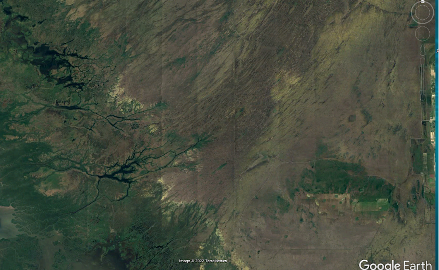
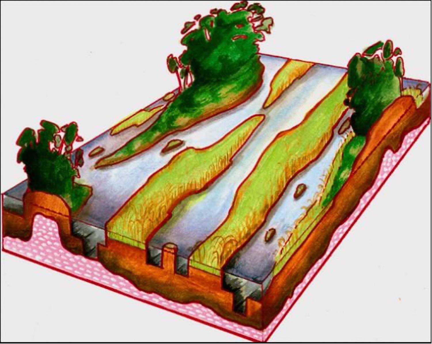
Just like some rivers create their own channels, the water and geology have formed a corrugated, ridge and slough landscape in the Everglades. Water flows through sloughs, while the ridges have higher elevations that act as river embankments that trap sediment.
However, the elevation difference between the ridges and sloughs is slight, ranging from 1.65 to 3.3 feet, and ridges remain underwater for most or all the year. Nonetheless, the ridges help create high water levels locally and support a bundle of life in the Everglades.
When water levels fall during the dry season, the sloughs provide critical deeper water habitat for fish and aquatic invertebrates. These sloughs concentrate prey for wading birds, creating a feast for them during their breeding season. In its pristine condition, the central part of the Everglades was composed of multiple channels following complicated patterns like twisted strings of yarn. The ridges and sloughs formed many “rivers” in the Everglades, lazily flowing right next to each other.
The End Of The Journey
After quietly and slowly crossing through the ridge and slough topography in Everglades National Park, and gently passing through creeks that traverse the mangrove swamp, the water of the Everglades gracefully surrenders itself to the Gulf of Mexico on the southwest and Florida Bay to the south. Like the mouth of a river, the water flowing into Florida Bay travels a wide array of paths before its final plunge to freedom. River mouths are often good places for fishing, much like the fishing capital of the world, Florida Bay.
And the Everglades is . . .?
Now that we’ve followed the gently flowing River of Grass from its source to its azure end, we pull back the curtain on the identity of the Everglades. Was Marjory Stoneman Douglas’ “river” label, right? Or were “grassy waters” a better description? Turns out, they both were correct. The Everglades is a grass-filled wetland with interconnected river channels formed by the ridge and sloughs. It is a complicated river, whose riverbed and banks are covered by wetland plants. It may not be a typical one, but there is a “river” in the River of Grass.

Satellite view of the Everglades ridge and slough/Google Earth
Is The River Of Grass In Danger?
Now that we finally know the true river-like nature of the Everglades, we face a sobering fact. These unique characteristics that make the Everglades a River of Grass are in peril.
About half of the Everglades has been lost to development, while what remains is threatened by degraded water quality, altered hydrology, climate change, and invasive species. The ridges and sloughs are no exception, and these characteristic corrugated features have been gradually flattening.
The National Academies of Science, Engineering, and Medicine hypothesized that these changes are caused by intermittent flows, conditions that are too dry during the dry season, and too much water during wet season. Yet, these ridges and sloughs are critical for the health, well-being, and survival of the Everglades ecosystem and the many species that call it home.

An illustration of the Everglades ridge and slough landscape showing features like tree islands and water flow paths/The Ridge and Slough drawing modified from original conceptualized by Chris McVoy, SCT 2003
How Can We Help?
Fortunately, there is a solution. If you haven't heard of it, there is an ongoing effort to restore the Everglades. More freshwater flow, particularly during the early dry season, will help avoid excessive dryness that causes the ridges to lose vegetation, ultimately causing them to flatten.
Limiting the high-water levels during the wet season also helps protect tree islands and their inhabitants. Keeping water above ground for longer periods of the year is also recommended by scientists.
To achieve this, a key element of restoration is a water storage reservoir that is currently being constructed in the Everglades Agricultural Area south of Lake Okeechobee. It’s a milestone that will provide freshwater for the Everglades when it’s needed and solve the problem of excessively high water during wet season. A reliable source of clean freshwater for the Everglades is predicted to rehabilitate its topography and bring it back to a true River of Grass.

Comments
Fascinating article and beautifully written!
There is no place else like it on earth. So much diversity in flora and fauna. There are surprises at every turn. Guided trips in the sloughs and trips to Flamingo are educational fun! We must preserve what is left! Every school child in Florida deserves a field trip! If not that, than a school-wide building of a model of how the Everglades work and their value to the environment. So much to learn so that commercialism can no longer destroy our Everglades.