
Glen Canyon Dam/Water Desk, Ted Wood
Archaeological Sites In Grand Canyon Degrading Due To Glen Canyon Dam
“These are the days of miracle and wonder" -- Paul Simon, Boy in the Bubble
By Patrick Cone
Paul Simon sings of dry winds sweeping across the desert and lasers in the jungle, in his song Boy in the Bubble. While not exactly the jungle, scientists have been using lasers to map windblown sands on archaeological sites deep within Grand Canyon National Park, which have been impacted since the 1963 construction of the Glen Canyon Dam upstream.
The problem is the dam has greatly reduced the amount of site-burying sediment carried downstream by the Colorado River. Park staff long have noted that “erosion, deterioration, and loss of archaeological sites are among the documented impacts on the sediment-starved river.”
To better quantify the impacts, the U.S. Geological Survey’s Grand Canyon Monitoring and Research Center, along with the Glen Canyon Dam Adaptive Management Program, from 2010 through 2020 surveyed and monitored 30 archaeological sites in 23 locations along 200 miles of the Colorado River corridor. The USGS just released a report, co-authored by Joshua Caster, Joel B. Sankey, Helen Fairley and Alan Kasprak, that documents the degradation caused by dam operations.
The researchers used high-resolution terrestrial light detection and ranging equipment (Lidar) during their surveys. Lidar uses a pulsed laser light that measures and maps distances, ranges, and surface anomalies. These ancient sites included vestigial campsites, rock art, rock dwellings, irrigation systems, and agriculture areas. Some sites date back more than 9,000 years, the oldest of which tend to be more deeply buried in the shifting sands. But other more recent sites have been exposed by the changes in waterflows within the canyon. The study area included recent historic areas, such as the old Lees Ferry crossing, mining claims, and settlement areas.
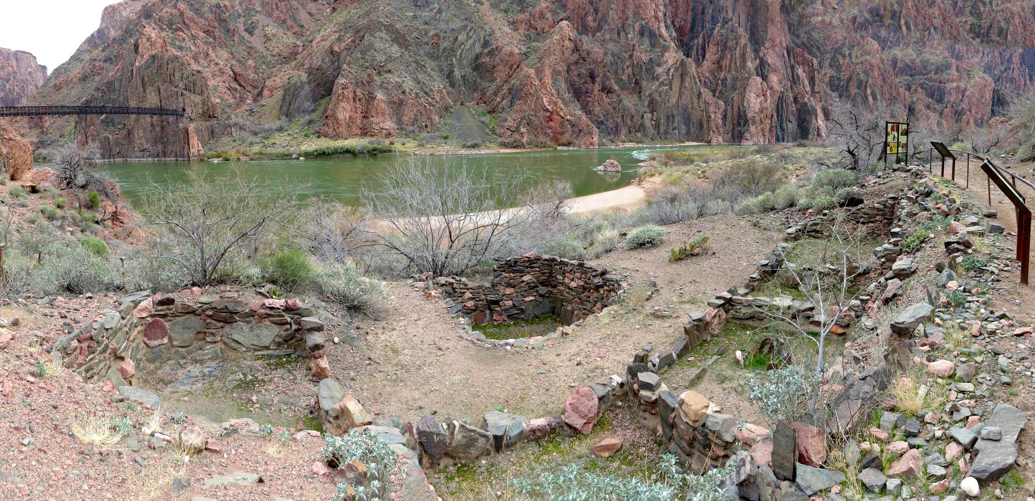
There are rich archaeological sites in Grand Canyon, including the Bright Angel Pueblo, and some are being impacted by operations of the Glen Canyon Dam/NPS file, Michael Quinn
Overall, the report, while not detailing specific impacts to the sites, noted that dam operations significantly degraded nearly all sites, with 21 of 22 sites in worse condition over the term of the survey.
When the Glen Canyon Dam gates plugged the natural flow of the Colorado River through the Grand Canyon in 1963 it wrought many changes, from reduced peak flows, loss of sediment, and even colder water temperatures. Sediment that once coursed through the canyon during spring runoff is now captured behind the 700-foot-tall dam. The loss of sediment impacted the downstream beaches and riverine spaces where native populations once lived. Degradation cited in the report attributed reduced sediment supply to reduced river sandbars, as well as the encroachment of vegetation.
“For thousands of years people lived along the river. The resources were buried, with annual flooding from the river. The change in ecology with the dam stopped the sediment from flowing. The sites were well protected until the last 40 years, when we started seeing erosion,” explained Jan Balstrom, the park’s chief for Communications, Partnerships & External Affairs. “The most recent work shows that there is desertification happening.
“Work continues to evaluate maintaining integrity of the properties by having stability with the sediments,” she added. “Without that, we’re in a losing proposition. The goal is ways to find ways to improve habitats, sandbars, sediment deposits above the old high-water marks.”

The recent lack of high-flow releases, such as this one in 2018, has prevented sediment from being carried downstream of Glen Canyon Dam in the Colorado River/NPS, Michael Quinn
Since 2012, dam operators have tried to mitigate these downstream impacts by periodically flooding the canyon by releasing high flows that can help rebuild sandbars and resupply dune fields, which then help cover ancient sites. But even with that, these sites are at risk. There hasn’t been a high release for four years now, as lower Lake Powell levels and the threat of introducing invasive small mouth bass downstream has precluded releases. And, in the meantime, degradation of beaches and sandbars, plus increasing vegetation, continues.
Report co-author Helen Fairley, a USGS social scientist, said, “It’s important to remember that archaeological sites along the Colorado River have been affected by wind, rain, and other natural processes for hundreds to thousands of years. Though these processes continue to affect the sites, Glen Canyon Dam has fundamentally changed many pre-dam natural processes.”
Lidar can map topographic changes created by shifting sands, erosion, and localized flooding. The survey is an important dataset that national park resource managers can use to manage the canyon and perhaps help plan mitigation to protect the sites. Mitigation might include more planned releases from the Glen Canyon Dam, including both high and low flows, to mimic springtime flooding that could rebuild beaches.
Jennifer Dierker, an archaeologist at Grand Canyon National Park, said the park is very supportive of Lidar work. “It helps us understand how the long-term dam operations change the landscape, and archaeological sites,” she said. “When we get high flows they deposit sand, and then the sand bars dry out. They identify places with alien transport, for example, windblown sand.”
While there were Lidar surveys in the early 2000s, those were conducted from helicopters and were not as accurate as the ground-based approach employed for the recent study. “Terrestrial LIDAR works well with greater control at that fine grain movement,” said Dierker.
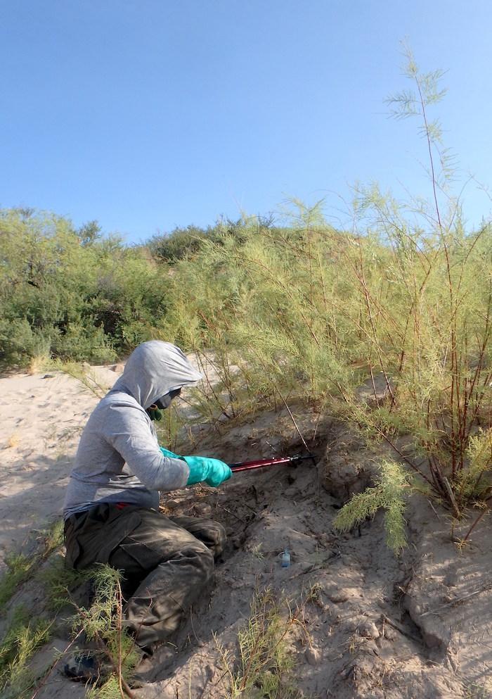
Crews tackle invasive vegetation along the Colorado River corridor in Grand Canyon National Park/NPS file
Another problem created by the disappearance of seasonal flooding is vegetative encroachment. As beaches dry out, grasses, shrubs, and trees find footholds and lock down the sand that in the past might have been picked up by the winds and deposited atop archaeological sites, burying them.
Invasive tamarisk trees now account for about a third of all woody vegetation in the canyon; its spread might have been controlled pre-dam by seasonal flooding that might prevent it from gaining a foothold. The National Park Service annually sends crews down into the river corridor to remove invasive vegetation.
Weather changes spurred by climate change could also pose a threat to exposed archaeological sites.
Sankey, a USGS research geologist and co-author of the latest study, told the Williams-Grand Canyon News, “There’s concern with climate change, we’ll continue to see an increase in the number of intense rainstorms during the (summer) monsoon. That’s something climate change modelers have projected (and) we’ve seen it in the rainfall records from recent decades in the Grand Canyon region. But if sites are buried by a protective cover of sand, they’re less susceptible to being damaged from rainfall runoff processes.”
Better understanding the threats to the canyon’s archaeological sites, and finding ways to mitigate them, is important to the park’s tribal partners.
“These places are important to tribal groups,” said Dierker, pointing to the inclusion of the Navajo, Hopi, Hualapai, Zuni, and Piute in any plans on these areas.
To that end, there are a number of formal closures in the canyon to protect sensitive archaeological sites. And, the 22 sites are not named in the report for even further protection.
“The results of the past ten years of monitoring archaeological sites with terrestrial lidar surveys has demonstrated that many sites are deteriorating; however, there are several management options available for slowing this ongoing degradation, including continuing use of high-flow experiments, vegetation removal, and potentially having lower flows during the spring windy season,” said Joshua Caster, a USGS geographer and co-author of the report.

Add comment