
The most glaciated peak in the contiguous U.S., Mount Rainier National Park / Rebecca Latson
It’s August, summer, and hot in many units within the National Park System. So, I thought it would be appropriate to have a quiz about water and water-related items/issues. You might even be thirsty after testing your knowledge on these questions before reviewing the answers at the bottom of this piece.
1. Mount Rainier National Park is one of the most glaciated peaks in the Lower 48, with a total of ___ major glaciers blanketing the sides of this “episodically active” composite volcano.
a) 20
b) 23
c) 25
d) 27
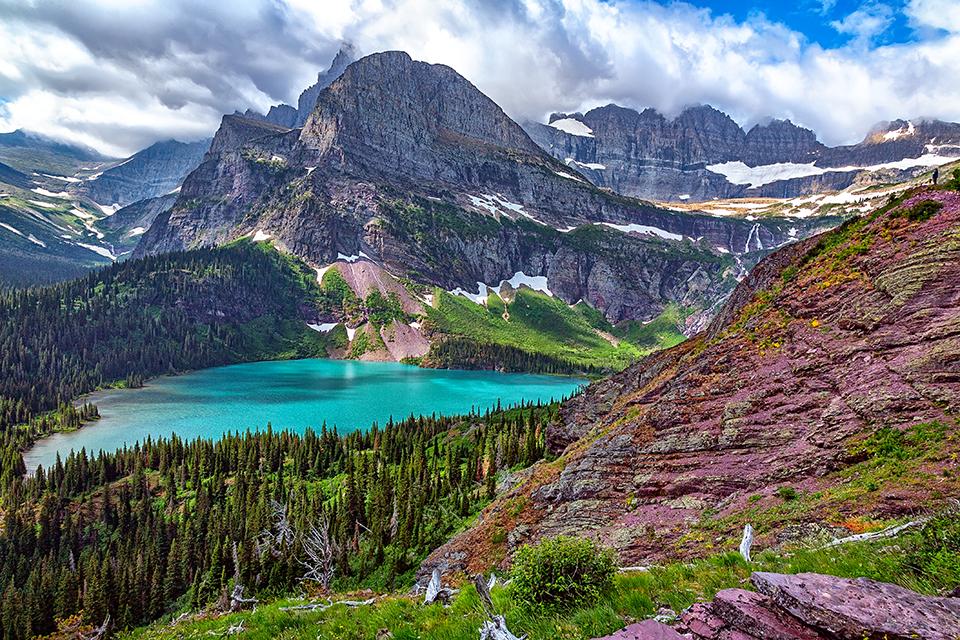
The turquoise beauty of Grinnell Lake, Glacier National Park / Rebecca Latson
2. “Thanks to past ice-ages, Glacier National Park has lots of water. Of the over 700 lakes Glacier, ___ are named.”
a) 127
b) 131
c) 135
d) 140
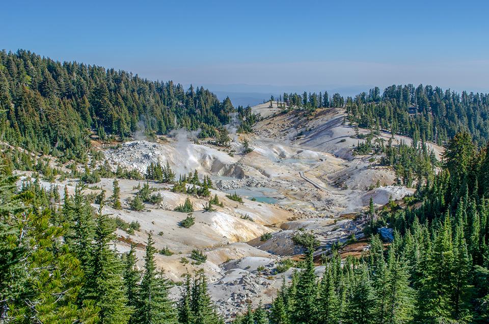
Looking out upon Bumpass Hell, Lassen Volcanic National Park / Amanda Sweeney
3. Bumpass (pronounced bump-us) Hell is the largest of ____ hydrothermal areas in Lassen Volcanic National Park.
a) Three
b) Five
c) Eight
d) Ten

Sunrise in the palms, Everglades National Park / NPS - Van Nimwegen via Flickr
4. True or False: Greater Everglades in Everglades National Park is the largest saltwater marsh in the United States.
a) True
b) False
5. Which national park has a tunnel bored beneath it to carry water from west of the continental divide to east of the divide?
a) Rocky Mountain National Park
c) Glacier National Park
d) Black Canyon of the Gunnison National Park

Badwater Basin - the lowest point in North America, Death Valley National Park / NPS - Weston Kessler via Flickr
6. Badwater Basin in Death Valley National Park is the lowest point in North America, at ___ feet below sea level.
a) 132
b) 176
c) 282
d) 297

Biscayne coral reefs, Biscayne National Park / NPS - Shaun Wolfe
7. Ninety-five percent of Biscayne National Park’s 173,000 acres is water, and there are ___ primary ecosystems within this park.
a) two
b) three
c) four
d) five

The ferry's wake on Lake Chelan, North Cascades Complex / Rebecca Latson
8. True or False, the lake after which Lake Chelan National Recreation Area (part of the North Cascades Complex) is named is the second deepest natural lake in the nation.
a) True
b) False
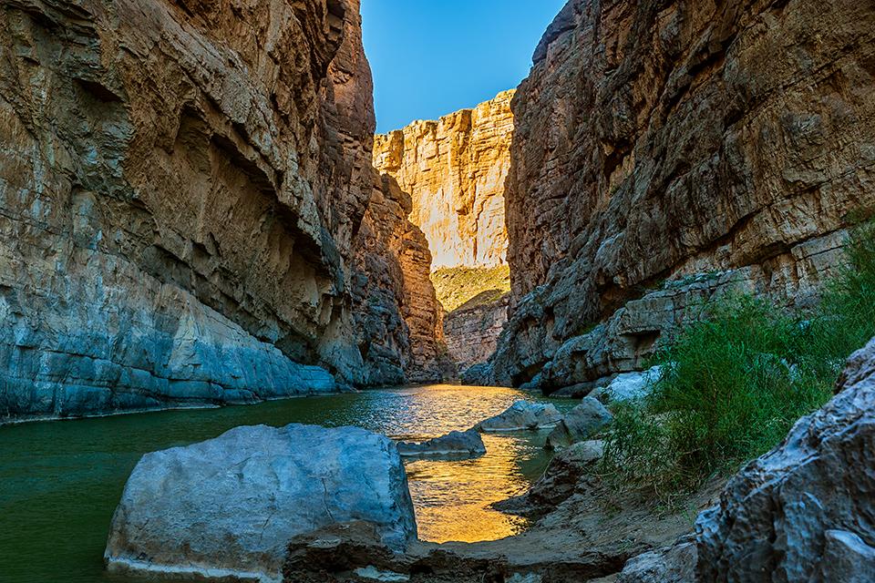
The flow of the Rio Grande through Santa Elena Canyon, Big Bend National Park / Rebecca Latson
9. “In 1978, Congress designated a 196-mile portion of the Rio Grande as part of the National Wild and Scenic Rivers System. Only the upper ___ miles of the Wild and Scenic River lie within Big Bend National Park’s boundary.
a) 69
b) 78
c) 87
d) 92

A snow trail toward "The Mountain," Mount Rainier National Park / Rebecca Latson
10. “The Paradise area at Mount Rainier (elevation of 5,400 feet) is known for its snowfall. Paradise once held the world record for measured snowfall in single year in 1971-1972, at ___ inches.”
a) 765
b) 966
c) 1,122
d) 1,644
Trivia

A streak of color on the Lower Falls, Yellowstone National Park / Rebecca Latson
Still waters run deep … and stay colorful. Look closely at this image of Lower Falls in Yellowstone National Park. Notice that streak of color in the otherwise white froth of water as it cascades over the edge? There’s a notch in the ground beneath that spot that allows for a deeper flow of the water before it hits the rockier, shallower portion of the falls and turns into to spray and froth. Fast-flowing water, shallower depths and rocky impediments tend to create rapids and froth.

The beauty of Voyageurs National Park / NPS
“Voyageurs National Park is home to many habitats, including rivers, forests, lakes, and wetlands. Wetlands have specific conditions that promote the growth of a rich variety of plant species, some of which can’t grow in any other habitat. Types of wetlands found in the park include marshes and bogs. These unique ecosystems help to clean the water and improve water quality, store floodwater and reduce flooding, and provide homes for amphibians, insects, fish, marsh birds, and semi-aquatic mammals.” To learn more about Voyageurs’ wetlands, click here.
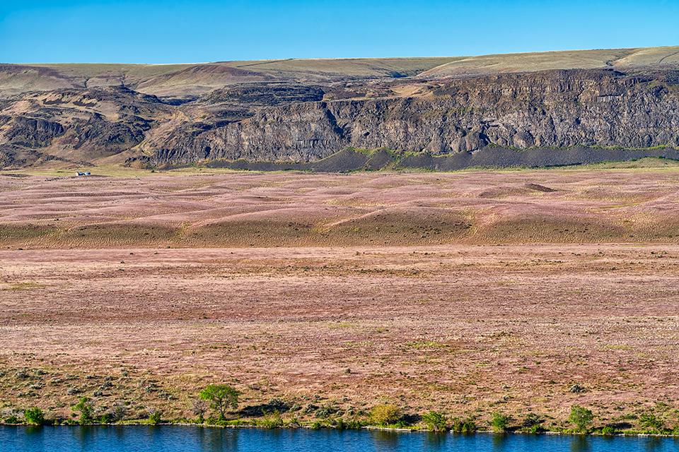
Mega ripples at Crescent Bar along the Columbia River, Ice Age Floods National Geologic Trail / Rebecca Latson
Road tripping along the route of the Ice Age Floods National Geologic Trail will take you to amazing, but often hot and dusty sights through Montana, Idaho, Washington state, and Oregon. Some 18,000 – 13,000 years ago, however, things were pretty wet as the floodwaters of Glacial Lake Missoula broke through the ice dam and surged through these states. In Montana and Eastern Washington, you’ll come across landscape features created by these humongous floodwaters, such as giant current ripples (aka mega ripples). These giant ripples are just like the ones you see along a river bank or lakeshore, only much, much, larger. You can see them at places like Camas Prairie in Montana, and along the Columbia River in Washington state. Viewing them at or above eye level, you might think they were moguls along a snowless ski slope. In reality, these giant ripple marks may measure 25- to 50-feet high and 100 – 250 feet wide. There’s even a Traveler photo article that talks about some Eastern Washington giant ripple marks you can see for yourself.
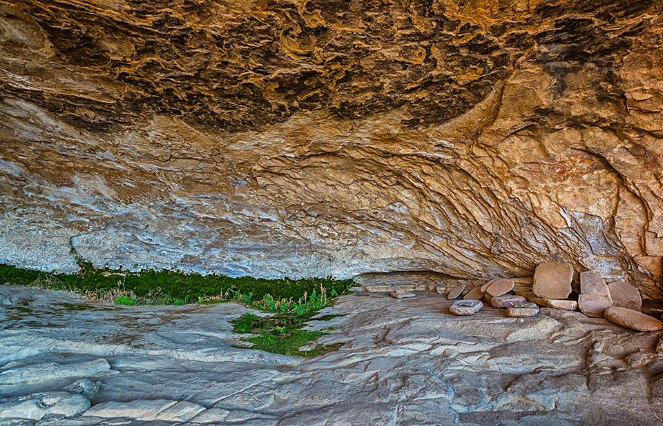
Manos, metates, and seeps at Long House, Mesa Verde National Park / Rebecca Latson
If you visit Mesa Verde National Park and take one of the tours to view the cliff houses close up, you may see spots along the back walls with greenery like the image above at Long House, on Wetherill Mesa. Those green spots are seeps and natural springs which were essential to the Ancestral Pueblo people, who “likely knew the location of every seep spring on Mesa Verde. They often managed the flow of water emerging from a cliff face by carving small depressions into the shale floor, channeling the water into small pools from which to collect the water.”
Quiz Answers
1c
“There are 25 major glaciers on Mount Rainier and numerous unnamed snow or ice patches, which cover about 35 square miles (90 km2).“ To learn more about this national park’s glaciers, click here.
2b
There are 131 named lakes in Glacier National Park. To read more about the lakes and ponds within this “Crown of the Continent.” Click here.
3c
Bumpass Hell is the largest of eight hydrothermal areas in Lassen Volcanic National Park. According to kqued.org news, this hydrothermal area received its name from one Kendall Bumpass, who led a group on tour there in 1865. "Kendall was warning everyone to be careful of where they put their feet and stepped because he knew how crumbly the ground could be. Unfortunately, he took a misstep, and his leg plunged into the boiling, acidic water. It burned him very severely."
4b False
Greater Everglades is the largest freshwater marsh in the United States. You can read about this “River of Grass” in this Traveler article, and listen to the Traveler podcast about “slough slogging”, and even watch a Traveler webinar about slough slogging and park funding.
5a
“As the lynchpin of the Colorado-Big Thompson Project, the 13.1-mile-long Alva B. Adams Tunnel enables Upper Colorado River Basin water to flow beneath Rocky Mountain National Park to East Slope water users.” To read more about the Adams Tunnel, click here.
6c
Badwater Basin in Death Valley National Park is the lowest point in North America, at 282 feet below sea level.
7c
The park consists of four primary ecosystems: a fringe of mangrove forest along the mainland shoreline, the southern expanse of Biscayne Bay, the northernmost Florida keys, and the northernmost portion of the third largest coral reef in the world.
8b
Lake Chelan is the third deepest natural lake in the nation. The deepest lake is Crater Lake in Oregon, followed by Lake Tahoe in Nevada/California.
9a
Only the upper 69 miles of the Wild and Scenic River lie within the park’s boundary; the remaining 127 miles lie downstream of the park’s boundary.
10c
“Paradise once held the world record for measured snowfall in single year in 1971-1972: 1,122 inches (93.5 feet/28.5 meters).” To see the annual snowfall in inches, from 1920 to 2021, click here.
References
In addition to the information taken directly from NPS websites for these National Park System units, I used the following publications and websites for reference.
John Soennichsen, Washington’s Channeled Scablands Guide, 2012, The Mountaineers Books
https://www.kqed.org/news/11633647/going-to-bumpass-hell-better-watch-your-step
https://www.activenorcal.com/how-this-mans-hell-became-one-of-norcals-favorite-destinations/
https://inside.mines.edu/UserFiles/File/Geology/Camas_red.pdf


Add comment