Editor's note: El Morro and El Malpais national monuments stand in western New Mexico, fewer than 50 miles apart. They both preserve rugged, demanding landscapes that nevertheless attracted travelers, from ancestral Puebloans to early 20th century homesteaders. El Morro was a waystation; here, at the base of a towering cliff was a reliable spring that for hundreds of years quenched the thirst of travelers. Many carved petroglyphs, names, and dates into the soft sandstone to show who came before. El Malpais, despite the broken lava fields that cover the landscape, nonetheless saw settlement as long ago as 1300. Today visitors study the signatures at El Morro, or peer into the lava tubes that worm beneath El Morro's surface. But there's also the backcountry of both that attract visitors who look for beauty, solitude, and perhaps a connection with those who came long before. Barbara Jensen was one such traveler.
Halfway between Albuquerque and Gallup in New Mexico, I turn south off the interstate, snow-dusted Mount Taylor rising in my rearview mirror. I am visiting two impressive national monuments: El Malpais and El Morro. While they are only about 40 miles apart, each monument is unique and meaningful, offering complimentary lessons when experienced on one trip.
El Malpais is Spanish for “The Badlands.” Cracked and jagged black lava tubes worm across the inhospitable land to my right, while pale, smooth, soft-looking sandstone bluffs climb steeply to my left. I stop to see La Ventana Arch, “The Window.” Standing at the base of this awe-inspiring 120-foot natural stone arch, I look up through it into the heart of the mountain. It feels like a metaphor for introspection, a time to look within, to see what I am made of. To remember.
El Malpais is known for its lava tube caves, some filled with ice even in summer. However, cave permits are not available this trip, due to COVID-19. Instead, I’m exploring back roads into multiple wilderness areas. At the southern end of the monument, I enter the West Malpais Wilderness. County Road 42 is a rough dirt road that comes with a permanent disclaimer warning me the road is impassable when wet, a large sign posted alongside the deeply rutted single-lane, four-wheel-drive track. I turn onto the even narrower road leading to Hole-In-The-Wall, an oasis of trees and grass growing like an island within a ring of rugged volcanic badlands.
Locking my vehicle at the trailhead, I set off with my full pack, hiking two hours in through a mixed conifer forest. Elk sign is frequent, and I’m hoping to see them. I pitch my tent on the high mesa where the trees have thinned a bit, on tightly tufted grasses sprouting through crumbled pumice gravel, a reminder of the volcanic origins of this area. As I cook supper on my campstove, a solitary raven circles low around me, twice, checking out this interloper in its territory before flying off to the deeper forest. Coyotes yip in the distance.
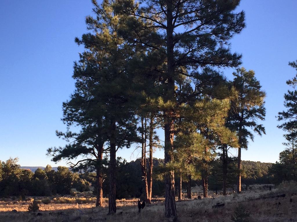
Open forests of the West Malpais Wilderness/Barbara Jensen
I awake to a thin dusting of frost on one side of my tent. The sun is trying to rise through building clouds. I drink my coffee, thinking, Bad place for wet weather, remembering the road sign far below me. I break camp and hustle back down to the paved roads. But these thick desert clouds soon stretch out, thinning before blowing away. Relieved by the clear skies, I take off to Cebolla Canyon. Here a 20- to 30-foot-deep crevasse gouges the earth, the walls of this dry streambed created as years of seasonal rains washed down the sandstone cliffs and carved through the thin soil of the lands below.
I hike along a side canyon on Lobo Canyon Trail. Again, the path is stamped with elk tracks. But this area has no water right now, and I find no elk, even in the box canyon at the end of the trail.
Further into Cebolla Canyon, I come upon the stone walls and foundations of several houses and outbuildings of homesteaders who persevered here from the late 1800s – early 1900s. The ruins stand, along with fences and gates of current-day ranching operations, as reminders of the odds of survival without regular, steady water sources. Beyond the ranches, the road leads to the Cebolla Wilderness, where I camp under the last shooting stars of the season.

Ruins slowly collapse in Cebella Canyon/Barbara Jensen
The next morning, I return to the main highway and turn back south, to the access road for Armijo Canyon Trail. I walk along old split fence posts, their rails long fallen. It is quiet here. The farther I walk, the deeper the sand of the trail becomes, leading as it does to the back side of Sand Canyon. I can’t shake the feeling that I’m trekking back across the sands of time.
Heading back to the trailhead, I take a side path into the arroyo itself, climbing over blocky stone formations that would create waterfalls and pools during monsoon runoff. The ancestral Puebloans who lived here, at a place now known as the Dittert Site, must have relied heavily on the seasonal pools, before the local climate changed and water became increasingly scarce. Areas of El Malpais have been accessed by the Acoma, Laguna, Zuni, and Ramah Navajo people for thousands of years, once building pueblos here, as well as continuing to practice cultural traditions today.
Intrigued by the many people who have tried to settle in the area, I decide to cross the Acoma-Zuni Trail over the rugged lava field at the heart of El Malpais. This route was created to keep the Acoma and Zuni people connected, for trading and cooperation in these harsh badlands. My trekking pole is not useful here, so I stow it in my pack; I need both arms for balance as I climb up and down over the sharp lava tubes, hopping over deep fissures in the black stone formations, an ongoing scavenger hunt as I locate the rock cairns that mark the way. This trail is sobering, the hot sun, deep sinkholes, and steep drop-offs forcing me to constantly reckon with what matters, namely, my preparation to meet the challenges I encounter.
The hike across the lava fields and back takes all day. I race against time on the return, moving quickly over the undulating lava hills as the sunset spreads a warm red glow under deep purple clouds. Even so, I find my final rock cairns by flashlight, as the daylight ends. Reaching the sandy part of the lower trail at last, I appreciate the softness underfoot, like a welcome home, to safety.
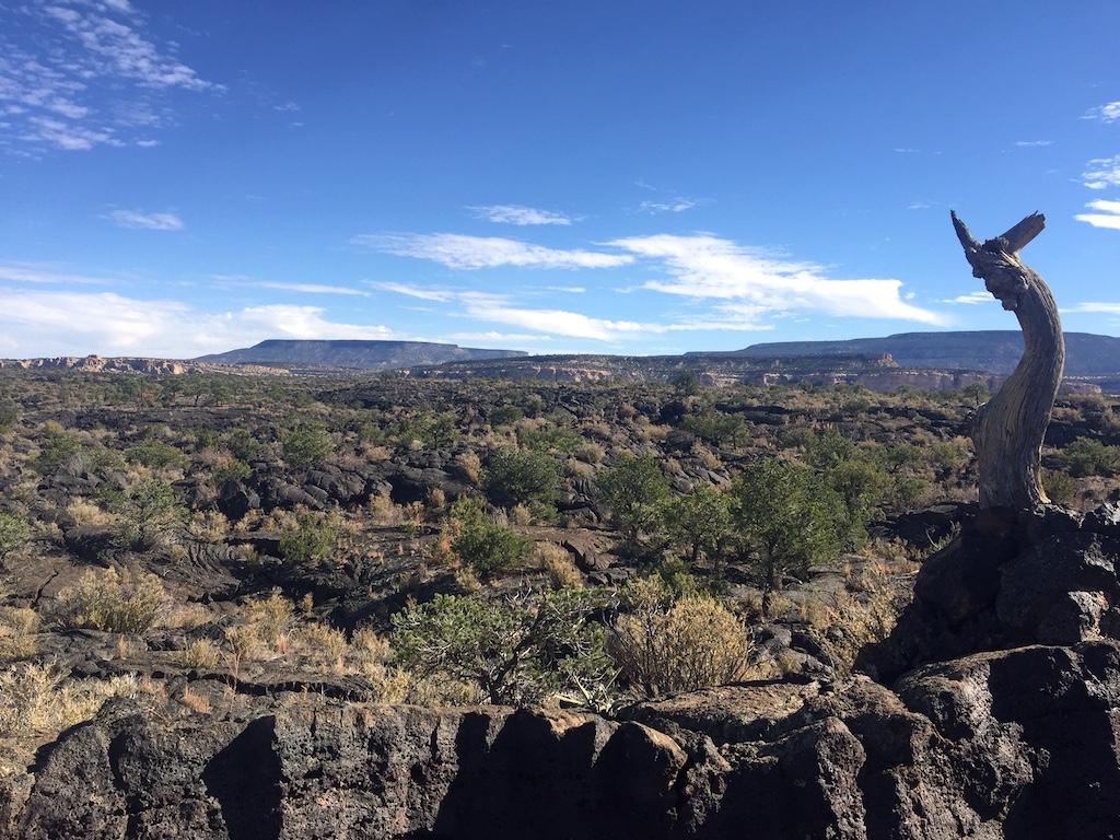
Broken lava dominates the Acoma-Zuni Trail at El Malpais NM/Barbara Jensen
On my final day in El Malpais National Monument, I drive Highway 53 to the west entrance, up a dirt road to a trailhead accessing part of the Continental Divide National Scenic Trail. This area is higher and more heavily forested. I hike southwest along the Chain of Craters, cinder cone hills along the western boundary of the El Malpais National Conservation Area (managed jointly by the National Park Service and the Bureau of Land Management). After passing several of the volcanic hills, I turn back at Cerro Lobo, crisscrossing the actual demarcation of the Continental Divide watershed in the process. I consider camping here and continuing this route tomorrow; but the area around Cerro Americano calls me back. It seems like perfect elk habitat, though there’s no water.
Twilight falls as I start pitching my tent near a ponderosa pine at the base of a forested hill. Coyotes, quite a number of them, howl – quite nearby. It’s exciting, and also makes me nervous. I quickly hang my food bag and then return to my tent, listening to the coyote pack greeting each other and communicating their hunting plans. After much animated yipping and calling, I hear them run off to the west.
An hour later, the moon has not yet risen. It is completely dark. Warm and dozy in my sleeping bag, I suddenly hear thunder. And then I feel the ground shaking beneath my tent.
I look out but cannot see anything. Yet I know: a whole herd of elk are running past me under cover of darkness. One animal huffs deeply as it lands from a leap over some obstacle, as if old or pregnant, out of breath and uncomfortable. I recognize the vocal tones, elk for sure. I watch the moving darkness out the window of my tent, trying for a glimpse of what I simply cannot see. The morning light reveals one of my tent cords hanging loose, its stake still lodged securely in the ground. As if kicked in passing.
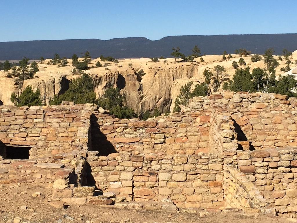
Ancestral Puebloans built homes atop the mesas of El Morro/Barbara Jensen
All of my travels through El Malpais now lead me to El Morro, as for so many travelers over hundreds and thousands of years. El Morro means “The Headland,” a landmark above the desert guiding me – to water. Hills rise to form a cuesta, a geologic feature with banded sandstone bluffs and cliffs forming a natural water reservoir at the center. The top of the formation acts as a self-contained watershed, bringing snowmelt and the runoff of desert rainstorms down walls and spillways; it funnels this precious resource to one vital spot, keeping the small, clear pool replenished no matter the season.
I walk the Mesa Top Trail, a loop that starts from the pool, travels alongside Inscription Rock, and climbs up through gamble oak and juniper across the top of the rocks themselves to the ruins of Atsinna, meaning “place of writings on the rock.” The Puebloan ancestors of the Zuni settled this place, undoubtedly for this water source in the badlands, leaving petroglyphs of lizards and birds, bighorn sheep and bear. And maybe elk, too, somewhere on Inscription Rock, amidst the names carved into this stone, names of Spanish conquistadors and Catholic Church bishops, U.S. Cavalry captains and Army expedition leaders, ordinary soldiers and scouts and homesteaders headed west.
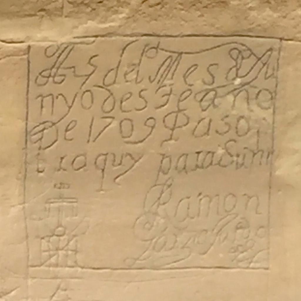
Roughly 2,000 carvings and inscriptions were made on the soft sandstone at El Morro/Barbara Jensen
I remember the guy I met at the highway gas station, as I left El Malpais and headed for El Morro. As I pumped my gas, he asked, “Would you have a quart of thirty-weight?” I did not have any oil, and knew how unlikely he was to reach his destination without it. As we talked about the area we found ourselves traveling in, he smiled despite his old truck’s need for oil. “When I get to Gallup, I’m picking up a classic motorcycle. Going to fix it up, you know, then take it out to the desert and just ride. If you come by Gallup, I’ll buy you a beer, yeah? And onion rings. Play you a game of pool.”
I asked him his name. “Marland. It’s European. Means ‘land by the water.’” He got back in his truck. “You see an old guy with a beard ride by on a motorcycle, you give a wave. It’ll be me.”
Pasamos por aqui, the inscription at El Morro reads. “We are passing here.” We follow the backroads of history, and trails across the badlands we all will inevitably encounter on our journeys. We also remember those who came through the wilderness before us, their words and ideas the landmarks they left for us, like fences and trails and elk tracks, showing us the way to find what we seek. And what we need. Like companions for the journey, offering us what they have to share. These trails are well-marked at El Malpais and El Morro national monuments, to help us make our way safely.
Barbara Jensen is a writer and artist who likes to go off-grid, whether it's backpacking through national parks, trekking up the Continental Divide Trail, or following the Camino Norte across Spain. For over 20 years, social work has paid the bills, allowing her to meet and talk with people living homeless in the streets of America. You can find more of Barbara's work on Out There podcast and www.wanderinglightning.com Follow @wanderlightning [email protected]


Add comment