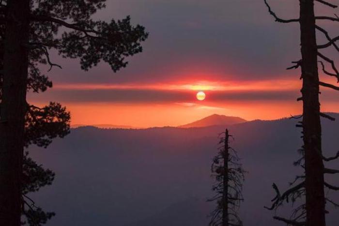
Sunset over the Ferguson Fire on July 23, 2018/USFS
Editor's note: This updates with decision to close Yosemite Valley, Wawona area of Yosemite National Park beginning Wednesday.
Visitors and overnight guests to the iconic Yosemite Valley and the Wawona area of Yosemite National Park will have to leave those areas by noon on Wednesday, as they'll close due to impacts of the Ferguson Fire burning in the Sierra National Forest to the west of the park, park officials said.
The officials did not provide details behind the decision to close all hotels, campgrounds, and visitor services in the Yosemite Valley and Wawona in a release sent out at midday Tuesday. Calls and emails to the park were not immediately returned.
According to the press release, with the ongoing closure of Highway 140, park visitors will have to exit the park via Highways 120 and 41. The temporary closure is expected to last until Sunday, July 29. The Mariposa Grove of Giant Sequoias is closed. Highways 120 West and East, and the Tuolumne Meadows area remain open at this time.
Since the fire began on Friday, July 13, several other park facilities and roads have been closed due to fire impacts and the need to support firefighting operations. These closures include the Glacier Point Road, Bridalveil Creek Campground, the Wawona Campground, the Merced Grove of Giant Sequoias and others. .
The Ferguson Fire was reported at roughly 36,600 acres Tuesday morning, with containment lines having been carved around a quarter of the fire's footprint. In Sequoia National Park, the Horse Creek Fire was still reported at just 30 acres, with containment lines around 17 percent of the fire. Finally, the Carr Fire at Whiskeytown National Recreation Area was covering an esimated 2,500 acres with just 5 percent contained.
"The Ferguson Fire was relatively calm throughout much of the area Monday as a heavy inversion layer kept fire activity to a minimum while crews worked to complete containment line on all fronts," Tuesday morning's fire report read. "Firefighters are building a mix of handline and dozer line on the Stanislaus National Forest to build indirect line working up Soapstone Ridge, opening old roads near the burn scar of the 2014 Rim Fire. From there, the line heads east toward Eagle Peak and down to El Portal. Crews will strengthen and improve lines today.
"On the Sierra National Forest side, containment line is in place from Jerseydale across to Wawona Campground and crews will continue to plan and be ready to implement strategic firing operations to help build a wider buffer to stop the fire’s spread," it added.

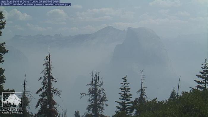
The Ferguson Fire was sending smoke into the Yosemite Valley on Tuesday morning/NPS webcam
The Ferguson Fire had been sending clouds of smoke into the Yosemite Valley. "Expect poor air quality and visibility due to the Ferguson Fire. Smoke may be heavy at times: limit activity during the periods of poor air quality," park staff warned visitors. "Some facilities and services are closed or diminished; check at visitor centers for details."
The Carr Fire in Whiskeytown National Recreation Area was reported Monday afternoon and quickly spread to an estimated 2,500 acres. An evacuation order was in place for French Gulch and Whiskey Creek Road north of Highway 299 and State Route 299 west of Trinity Mountain Road to the base of Buckhorn Summit, and an evacuation center was opened at Weaverville Elementary School and at Shasta High School for residents east of Trinity Mountain Road.

A wildfire at Whiskeytown National Recreation Area quickly blew up to 2,500 acres/ via @publiclandlvr
In Sequoia, helicopters ferried both ground crews and water dumps to the Horse Creek Fire burning in the park's John Krebs Wilderness Area.
"Firefighters continue to be challenged by steep terrain and high temperatures. However, a predicted stable air mass moving into the region will likely decrease the threat of thunderstorms," fire bosses reported Tuesday morning. "Fire behavior has remained moderate, with the fire creeping and smoldering along the ground."
The fire covered only about 30 acres. Over the weekend air tankers were used to drop retardant on the flames, as the following video shows.
The fire was sending some smoke into the Mineral King Valley, and there was a temporary hold on wilderness trips starting from Mineral King trailheads.


Add comment