
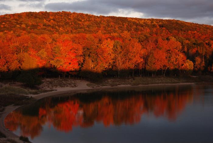
School Lake at Sleeping Bear Dunes National Lakeshore is a perfect fall destination/NPS
Taiga is a word of just two syllables, and yet it connotes remoteness. Its synonym – boreal – is slightly more familiar, though it too conjures the distant, the mysterious. But if you travel to the Great Lakes, to the national lakeshores that line the southern shores of those inland oceans known as Superior and Michigan, you can find yourself deep in the coniferous forests, the taiga or boreal forests, more familiar to the Canadian landscapes to the north.
In fall the remnants of these forests are found at Apostle Islands National Lakeshore in Wisconsin, and Pictured Rocks National Lakeshore a bit farther east in Michigan. The evergreens stand out against the showy, flaring golds, reds, and oranges of the hardwood stands of maples, beeches, and yellow birches, of the northern deciduous forest. To the southeast on Lake Michigan, Indiana Dunes National Lakeshore in Indiana and Sleeping Bear Dunes National Lakeshore in Michigan have another key feature often associated with water: dune systems.
While lakeshores might inspire dreams of balmy summer vacation spots, the fall months along the country’s northern tier are as enticing and colorful as those in the Appalachians and the Rockies. Yet they’re still mostly undiscovered as fall destinations.
“Fewer visitors means more solitude and almost private beaches and trails. The pace is slower and the sites visited are more thoroughly enjoyed,” says Susan Reece, chief of interpretation for Pictured Rocks. “The temperatures are moderate and there are few insects. With our maple-dominated hardwood forests, the fall colors are spectacular.”
Sound intriguing? Let’s take a somewhat closer look at each of these lakeshores.
Apostle Islands National Lakeshore
Twenty-one islands (actually 22, but more on that later) make up this national lakeshore, which was established in the fall of 1970. Paddling out to some of these islands in the fall is only recommended for experienced kayakers, but there are boat tours and ferry services that run through September and into October. Once you’re on an island, the possibilities open up.
“Hiking the trail to the Sand Island Lighthouse in the fall would be spectacular,” says Apostle Islands Superintendent Bob Krumenaker. “Red sandstone lighthouse, against blue water, northern hardwoods in fall foliage. But you’d need your own boat to get there.”
Even better, he says, would be to venture far out to Outer Island, which is obviously named for its remote location.
“My absolute favorite place to watch the sunset is the Outer Island sand spit,” Superintendent Krumenaker said, adding, though, that 3-to-5-mile stretches of open water crossings can make that paddle particularly dangerous.
But really, you don’t need to risk your life to enjoy fall in the Apostle Islands. The 55-mile “Grand Tour” cruise ($39.95 for adults, $23.95 kids 6-12, $1 for those under 6) offered by concessionaire Apostle Island Cruise Services through October 18 leaves Bayfield to navigate through the heart of the Apostle Islands’ archipelago. The company also shuttles paddlers and island campers, though this service runs only until September 6.
There are a number of other businesses that perform shuttle services. Contact them directly for their rates and operating schedules. Visit the Apostle Islands during the first two weeks of September and you can attend the 20th annual Lighthouse Festival. This cruise-based celebration involves guided boat tours to the lakeshore’s lighthouses. Schedules and pricing can be found at www.lighthousecelebration.com/ schedule--rates.html.

Solitude and spectacular sunrises are best enjoyed on Julian Bay in Apostle Islands National Lakeshore / NPS
Prefer to go it alone? Paddle, or take a ferry, out to Stockton Island. Pitch your tent at the Presque Isle Campground, and rise early to watch sunrise from Julian Bay on the other side of the point.
“It’s one of the most beautiful parts of the park any time of year,” the superintendent says. “It’s a semicircular bay that looks out on the open water of Lake Superior. If you’re there in September or October, you’re most likely going to be the only one there.”
On the mainland, the Lakeshore Trail is the single best, most accessible, path in the fall. It leads to overlooks of the lakeshore’s fabled sea caves, provides views of the pounding Superior, and, of course, there’s a kaleidoscope of fall colors.
Oh, and the 22nd island? That would be Madeline, which is not part of the national lakeshore, but does feature Big Bay State Park, as well as the Madeline Island Historical Museum, which showcases the region’s fur trade era. ~ Kurt Repanshek
Sample the Historical Side to the National Lakeshores
Devils Island Light is among the classic collection of lighthouses and stations at Apostle Islands National Lakeshore / NPS

No matter which national lakeshore you visit, add these nautical elements to your vacation agenda. Lighthouses and light stations were built to keep ships off the shoals, and you can see them at Apostle Islands, Pictured Rocks, and Sleeping Bear Dunes national lakeshores. Plus, U.S. Life-Saving Service Stations, built with an eye to rescuing those unfortunate sailors whose ships did founder, are found in both Pictured Rocks and Sleeping Bear Dunes national lakeshores.
Apostle Islands has the best collection of lighthouses and light stations and, in fact, it’s the richest collection in the United States:
• Devils Island Light (Built in 1856)
• Old LaPointe (Long Island) Light (1858)
• New LaPoint Light Tower (1897)
• New Michigan Island Light Tower (1890) • Old Michigan Island Light (1857/1880)
• Outer Island Light (1874) • Raspberry Island Light (1862) • Sand Island Light (1881)
• Chequamegon Point Light Tower, Long Island (1897)
* Ashland Harbor Breakwater Light (1915)
Some of these facilities are quite rundown and in need of preservation, while others are currently undergoing preservation. Others are in fine shape. At the Old LaPoint Lighthouse, for example, all that remains are the foundation ruins. Raspberry Light, meanwhile, is in the best condition, having been remodeled and refurbished in 2006-2007.
The U.S. Life-Saving Service was created by Congress in 1878. While the first stations were built along the Atlantic Ocean, they soon could be found along the Great Lakes and the West Coast. In 1915 the Life-Saving Service gave way to the U.S. Coast Guard, but not before 279 stations were built. It’s estimated that more than 177,000 lives were saved by the men assigned to these stations. On the Great Lakes, find these stations:
• Grand Marais Lifeboat Station. Pictured Rocks National Lakeshore. 906-387-2607.
• Munising (Sand Point) Lifeboat Station, Pictured Rocks National Lakeshore, 906-387-2607.
• North Manitou Island Life-Saving Station, Sleeping Bear Dunes National Lakeshore, 231-326-5134.
• Sleeping Bear Point Life-Saving Station, Sleeping Bear Dunes National Lakeshore, 231-326-4700.
• South Manitou Island Life-Saving Station, Sleeping Bear Dunes National Lakeshore, (not open to the public).
For more reading: Lighthouses, Sentinels of the American Coast The U.S. Life-Saving Service, Heroes, Rescues and Architecture of the Early Coast Guard
Indiana Dunes National Lakeshore, Indiana
Fall is a nice time to visit Indiana Dunes National Lakeshore. The summer visitors are gone and the trails and beaches are less crowded. After Labor Day, all areas of the park are fee-free, except entrance to the Indiana Dunes State Park, located within the boundary of the national lakeshore. For fall colors, take a walk on the Glenwood Dunes Trail. With side trails and extensions, you can walk anywhere from one to 6.4 miles in a loop.
Horses are allowed on a portion of the Glenwood Dunes Trail—the only horse trail in the park. The elevation is mostly level with gentle rises and dips through the Glenwood Dunes, oldest of three earlier shorelines preserved in the park’s geography.
Another nice fall walk is through the Miller Woods unit of the park. This dune and swale area features tranquil views of ponds (where you might spot a beaver or two) and oak savannah, where deer are common. Start at the Paul H. Douglas Center for Environmental Education where rangers can give you tips on current conditions, bird sightings, and ranger-led activities. Enjoy hands-on family activities at the center, especially the outdoor Nature Play Zone where unstructured play is encouraged.

Walking the lakefront on Indiana Dunes National Lakeshore in fall melds the landscape to the water setting/NPS
If the weather is good and the lake is calm, fall is a good time to kayak the Lake Michigan Water Trail—a National Recreation Trail. There are numerous areas to put in and take out your kayak along the park shoreline. A personal flotation device is essential for paddling on the unpredictable lake.
Cycling is increasingly popular in northeast Indiana and new trails and trail sections are constantly opening. Check these sites for the most current information:
http://nirpc.org/media/3618/ greenwaysbluewaysmap_west.pdf
http://nirpc.org/media/3621/ greenwaysbluewaysmap_east.pdf
Of special interest – and high public demand – is the annual tour of four historic homes from the 1933 Chicago World’s Fair. This one-day event, held each October, will be on Saturday, October 17. These limited tours are available by reservation only. Each tour lasts two hours and includes an inside look at the Cypress Log Cabin, Florida Tropical, Armco Ferro, and the Wieboldt-Rostone houses.
The original 1933 “Century of Progress” houses featured innovative building materials, modern home appliances, and new construction techniques for their time. The houses were moved to northwest Indiana in 1935 to promote a new housing community and were included in the national lakeshore boundary in the early 1970s. Today, the historic homes are undergoing rehabilitation with private funds through a partnership with Indiana Landmarks and private citizens.
Tickets can be purchased on September 14 starting at 8 a.m. through the Dunes National Park Association website at DunesNationalPark.org. Tickets often sell out in only a day or two. If you have questions, please call the national lakeshore information desk at 219-395-1882. ~ Costa Dillon, former Indiana Dunes National Lakeshore superintendent
Pictured Rocks National Lakeshore, Michigan

You might share the Pictured Rocks lakefront with a seagull at the mouth of Hurricane River/NPS
At Pictured Rocks the sandstone cliffs that inspired this lakeshore’s name are rimmed with hardwoods, a contrast to the boreal woods. Frothy waterfalls plunge, some directly into Lake Superior, from these ruddy sandstone walls.
“Hike to Chapel Falls and continue to Chapel Rock and the beach,” suggests Chief Reece. “Munising Falls is an easy 800-foot walk.”
Paddlers have more than 40 miles of Lake Superior shoreline to explore via sea kayak. And if the lake is too treacherous, well, there are nearby hikes. “Some 90 miles of trail wind through 73,000 acres at Pictured Rocks. Much of the mileage follows the high cliffs above the lakes,” Traveler contributor Greg Breining noted in a summer story on Pictured Rocks. “We hiked to the precipice of Spray Falls, where Spray Creek launches into thin air in a free fall to the lake, and we walked White Pine Trail beneath mammoth beeches and hemlock. We were barely able to clasp our arms around a hemlock – at least 10 feet around.”
Or, you could head inland to Beaver Lake and Grand Sable Lake with your boats.

While Lake Superior is gorgeous, the colors that fire the forests at Pictured Rocks are even more so/NPS
As with Apostle Islands, you’ll find boat tours that run out there into mid-October to help with your explorations.
“Pictured Rocks Cruises, Inc., offers non-stop narrated boat tours of the spectacular sandstone cliffs within Pictured Rocks National Lakeshore,” the park notes. “Each cruise is 2-1/2 to 3 hours long and travels approximately 40 miles round trip.”
The cruises, which depart from downtown Munising, Michigan, run $37 for adults, $10 for kids 6-12, and $1 for those under 6. You can choose from the “Regular Cruise” that runs 32 miles and shows off the lakeshore’s colorful cliffs and sea caves, slowly cruising past Lovers Leap, Indian Head and Miners Castle; “Spray Falls Cruise,” which takes you by this 70- foot waterfall; and the “Sunset Cruise,” which follows the same route as the Regular Cruise, but later in the day to ensure you get the most vivid photos of the sun-soaked sandstone cliff faces.
Fall, as Chief Reece noted, is a great time to be out in the lakeshore, thanks in part to the lack of insects. Which makes camping a perfect way to experience the lakeshore, whether you find a site with Lake Superior access or head into the nearly 12,000-acre Beaver Basin Wilderness. The Wilderness includes 13 miles of Lake Superior shoreline from Spray Falls on the west to Sevenmile Creek on the east.
Hope to time your visit to peak fall colors? They can appear anytime between the last week of September and the end of the first week of October. ~ Kurt Repanshek
Sleeping Bear Dunes National Lakeshore, Michigan
Is there any more bucolic setting among the national lakeshores than that found at Sleeping Bear Dunes? Farms quilted like patchwork into forests, pocket lakes, and the sweeping 35 miles of Lake Michigan mainland shoreline greet visitors to Sleeping Bear.
This is a sprawling lakeshore, pulled together from nearly 2,000 individual tracts. In autumn, the landscape erupts in color as the beech-maple hardwood forests slowly become cloaked in their fall finery.
While there are scenic drives to be enjoyed at Sleeping Bear, this is a lakeshore that begs you to park the car and get out and explore. There are towering, 400-foot-high dunes to climb, a century-old lighthouse to visit, and stories of bravery held in three historic stations of the U.S. Life-Saving Service.
And, frankly, there’s the peacefulness of the lakeshore to relish.
“Shell Lake is a really nice, secluded inland lake. It’s good for fishing (Bluegill, Northern pike and Smallmouth bass) and solitude,” says Superintendent Dusty Shultz. “If I had to pick one lake surrounded by wilderness to visit, it would be Shell Lake.”
Perfect fall conditions can turn the landscape hugging North Bar Lake at Sleeping Bear Dunes incandescent/NPS
“Wilderness” is a new aspect of Sleeping Bear. It was March 2014 when President Barack Obama signed into existence the 32,557-acre Sleeping Bear Dunes Wilderness. Cradling the shoreline on the northern and southern ends of the lakeshore, and surrounding the park’s namesake mother bear and her windswept dunes in the center, the wilderness preserves a place that the Ottawa and Chippewa tribes called home for 3,000 years.
The wilderness area, which also holds the not-quite-100-acre Shell Lake, just might be the most accessible in the National Park System. County Road 22 skirts it, and Route 669 even bisects it, to provide access to the bay and a picnic area.
“The nice thing about Shell Lake is there are no houses or anything around that whole lake,” the superintendent points out. “You’re out there, the lake and hills around you.”
It’s a perfect setting for a fall canoe or kayak paddle.
Other not-to-miss fall sites include Pierce Stocking Scenic Drive, with its iconic covered bridge; the Port Oneida Rural Historic District with its farms, and; the Sleeping Bear Heritage Trail, a multiuse paved trail that runs more than 17 miles from Empire past the lakeshore’s “Dune Climb” and through the village of Glen Arbor to Port Oneida.
Crystal and Platte rivers also have great, watery, platforms from which to enjoy the season. Slowly navigating either one in a kayak brings the scenery, and wildlife, up close.
Also worth a visit are the wilderness settings of South and North Manitou islands, which Native American legend tells us were created by the Great Spirit Manitou to mark the watery graves of two bear cubs fleeing a forest fire on the Wisconsin side of Lake Michigan. Ferries run from Leland, just north of the park’s mainland setting, to the islands, but only into early October.
While sea kayakers can paddle out to the islands from the mainland, the tricky waters of Lake Michigan test even the most-experienced paddlers, and fall storms can create treacherous conditions. Paddle smart, and have fun. ~ Kurt Repanshek
No matter which lakeshore you choose to explore this fall, you won't be disappointed.


Add comment