The White House announced Sunday that President Obama would seek wilderness designation for much of the Arctic National Wildlife Refuge in Alaska/White House
President Obama, in a move certain to generate controversy, is pushing for the country's largest Wilderness designation to be bestowed on the Arctic National Wildlife Refuge in Alaska. Additionally, the Democrat wants four rivers -- the Atigun, Hulahula, Kongakut, and Marsh Fork Canning -- to be added to the Wild and Scenic Rivers System.
Only Congress can designate Wilderness areas, and with the Republican Party in control of both the House and the Senate, and past interest from the energy sector for drilling in the wildlife refuge, the president's proposal likely could go nowhere.
Interior Department officials said Sunday that the department is releasing a conservation plan for the refuge that for the first time recommends additional protections, and that President Obama will make an official recommendation to Congress to designate core areas of the refuge ' including its Coastal Plain ' as wilderness, the highest level of protection available to public lands. If Congress chooses to act, it would be the largest ever wilderness designation since Congress passed the visionary Wilderness Act over 50 years ago.
'Designating vast areas in the Arctic National Wildlife Refuge as Wilderness reflects the significance this landscape holds for America and its wildlife,' said Secretary of the Interior Sally Jewell. 'Just like Yosemite or the Grand Canyon, the Arctic National Wildlife Refuge is one of our nation's crown jewels and we have an obligation to preserve this spectacular place for generations to come.'
The president's decision builds upon years of public engagement by the U.S. Fish and Wildlife Service to revise the Comprehensive Conservation Plan (CCP) and complete an environmental impact statement (EIS) for the Arctic National Wildlife Refuge, as required by law. The plan will guide the Fish and Wildlife Service's management decisions for the next 15 years.
An Interior release said that, "(B)ased on the best available science and extensive public comment, the Service's preferred alternative recommends 12.28 million acres ' including the Coastal Plain ' for designation as wilderness. The Service also recommends four rivers ' the Atigun, Hulahula, Kongakut, and Marsh Fork Canning ' for inclusion into the National Wild and Scenic Rivers System."
Currently, more than 7 million acres of the refuge are managed as Wilderness, consistent with the Alaska National Interest Lands Conservation Act of 1980. However, more than 60 percent of the refuge ' including the Coastal Plain ' does not carry that designation.
Designation as wilderness would protect and preserve the refuge, ensuring the land and water would remain unimpaired for use and enjoyment by future generations. Only Congress has the authority to designate Wilderness areas and Wild and Scenic Rivers.
Recommendations for Wilderness or Wild and Scenic River designations require approval of the Service Director, Secretary of the Interior, and the President. The U.S. Fish and Wildlife Service on Sunday released the revised comprehensive conservation plan and final environmental impact statement (EIS) for the Arctic National Wildlife Refuge. While the Service is not soliciting further public comment on the revised plan/EIS, it will be available to the public for review for 30 days, after which, the record of decision will be published. At that point, the President will make the formal wilderness recommendation to Congress.
'The Arctic National Wildlife Refuge preserves a unique diversity of wildlife and habitat in a corner of America that is still wild and free,' said Fish and Wildlife Service Director Dan Ashe. 'But it faces growing challenges that require a thoughtful and comprehensive management strategy. The incorporation of large portions of the refuge into the National Wilderness Preservation System will ensure we protect this outstanding landscape and its inhabitants for our children and generations that follow.'
The revised plan/EIS addresses a variety of issues, including the protection of wildlife populations and their habitats, opportunities for fish- and wildlife-dependent recreation, subsistence needs of local inhabitants, and other public uses. The plan also strengthens wildlife and habitat monitoring, as well as the monitoring of public use of the refuge so as to better respond to changing conditions on the landscape, particularly those associated with climate change.
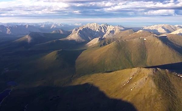
The 19.8-million-acre Arctic National Wildlife Refuge is home to the most diverse wildlife in the arctic, including caribou, polar bears, gray wolves, and muskoxen. More than 200 species of birds, 37 land mammal species, eight marine mammal species and 42 species of fish call the vast refuge home. Lagoons, beaches, saltmarshes, tundra and forests make up the remote and undisturbed wild area that spans five distinct ecological regions.
The refuge holds special meaning to Alaska Natives, having sustained their lives and culture for thousands of years. The Gwich'in people refer to the Coastal Plain of the refuge as 'The Sacred Place Where Life Begins,' reflecting the area's importance to their community, maintaining healthy herds of caribou and an abundance of other wildlife.


Comments
And Permafrost never reoccurs? The impact of permafrost isn't recreated. Those grounds weren't always in permafrost. And already the permafrost is 1 foot or more below the surface. What is impacting the surface three feet below and are the "changes" detrimental?
Those irreparable changes? One only need enter 'mountain topping' into Google, 4,890,000 responses come back in half a second. Click on images and you find such as this picture, and many more. One of the things I like living in Alaska is how beautiful it is. Not even the craftiest - or slimiest - real estate huckster could convince someone to build a house after this resource extraction technique.
This article I found is from that known left wing radical rag, National Geographic.
Well, a hopeful sign when Lee, I and ec all see a glimmer of common ground :-) I refer to Lee's question whether the oil under the Refuge could be "protected and held as an insurance policy against some future time when drilling for it might become critical." Ec says he'd have no objection if such a plan would actually be followed, and I could support that if the wilderness proposal fails, which seems almost certain at this time.
Any hope of that approach getting wide support would almost certainly have to be an agreement short of wilderness designation, and the challenge comes in defining "critical need" for the oil. I suspect any such plan would also find little support among Alaska's politicians, who crave the revenue windfall for their state that comes from the oil, and they want it sooner, not later.
Perhaps you weren't aware Rick, there is no "mountain topping" in oil/gas drilling. But hey, keep throwing out those strawmen. Much easier to attack than the truth.
As far as restoration ecbuck,I think the land in the Arctic is quite sensitive to disturbance. I've heard that it can take 100 years for scars on the land to grow back over. Some of the sedges and lichens are supposed to be hundreds of years old. After seeing what the phosphate companies call restoration" projects down here in Florida I would be somewhat leary about the oil companies doing restoration up there?? Mosiac and the other phosphate companies have caused havoc with the Florida land they mined. It was their land and they have the right to mine it. But they should tell the truth about what really happens to the land. They spend millions down here on TV ads talking about how they "restored' the land but all you have to do is see what it looked like before and what it becomes after.
Gutz - 100 years is a blink of an eye in the scope of the earth's history.
As to your phosphate companies - I don't know the particulars but I would be willing to bet that any failure is due to lack of effort to restore and not inability. I am 100% behind requiring the oil/gas drillers to restore.
I would also note that phosphate mining is far more intrusive than oil and gas drilling.
And then there is fracking. Developed by Halliburton, Dick Cheney's company. It has been exempted from many laws, except of course near Cheney's home where no fracking is allowed.
Anyone shilling for the oil companies in support of fracking has to be asked if they would want it in the lands under their own homes, and near their own aquifers. We don't want it in Alaska either.
Could you document that?
Since the EPA found once in 2004 that there is no impact on waters and their more recent study initiated in 2012 has not reached any contradictory conclusions I would be quite comfortable with fracking near my aquifers.
BTW - Sent any of that oil company money back yet?