A Rock Outcrop Management Plan has been adopted at Shenandoah National Park to protect these unique features/NPS
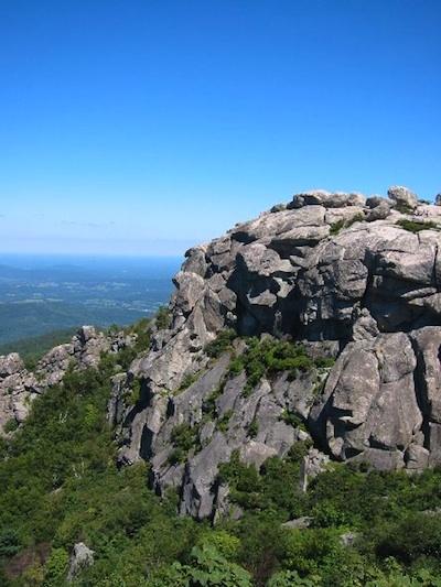
Rock outcrops at Shenandoah National Park, places such as Hawksbill, Old Rag, and Little Stony Man, offer great opportunities for viewing the surrounding landscape as well as climbing.
But concerns about visitor pressures on these features have led park officials to develop and adopt a Rock Outcrop Management Plan that aims to protect these natural features and their biological communities while continuing to allow visitor access.
Under the park's preferred alternative contained in an environmental assessment prepared for the management plan, officials say there will be "some minor restrictions to visit uses in certain areas of the park."
"Camping will be prohibited in portions of certain high elevation areas including Little Stony Man, Hawksbill, and North Marshall Mountains, as well as areas of Overall Run Falls North and Mary's Rock," a park release said. "Additionally, limited closures will be effected to protect high elevation resources in portions of Little Stony Man Mountain, Old Rag Mountain, and Hawksbill Mountain. Closures are effective immediately."
Though outcrops represent only a small area of the park, they are some of the largest outcrops in the region and serve as islands of unusual habitat supporting rare species assemblages. Given the relatively high elevation of many rock outcrops in the park, these areas provide habitat for unique communities of species that are typically only found in northern regions.
Rock outcrops are also very popular visitor destinations for hiking, rock climbing, camping and vista enjoyment at the park. The location of Skyline Drive along the ridgeline and the 500 miles of hiking trails provide exceptional access to many outcrops for a large number of the park's 1.1 million annual visitors. For example, one of the park's most popular hiking and climbing destination, Old Rag Mountain, has a summit area rich in rare species which is visited by an estimated 50,000 people annually. Visitation at one of the park's most accessible peaks (Stonyman Mountain) averaged 980 people per week during the summer and fall of 2002 (Hilke 2002). One popular climbing guide identified 27 separate rock climbing areas within the park, describing each area and the numerous climbing routes in detail (Watson 1998). The availability of trail information and outcrop locations, as well as the ease of accessibility to some of these outcrops makes them highly susceptible to impacts from intense visitor use.
Rock outcrops within the park and the natural resources associated with outcrops were a top management concern in the park's Backcountry and Wilderness Management Plan (NPS 1998) because visitor access, recreational use, and associated impacts to outcrop areas were known to be unrestrained and substantial.
'We have a legal obligation to protect these rare and sensitive plant communities and animal populations," said Shenandoah Superintendent Jim Northup. "As we begin formal implementation of the (Rock Outcrop Management Plan), we will continue to work closely with park partners and stakeholders to provide public enjoyment, while meeting these legal obligations.'
Under the plan, park staff will continue to monitor the status of rare natural resources and invasive plants, as well as visitor use and impacts on rock outcrops. Staff will also educate the public and cooperators on the importance of protecting rare resources at rock outcrops using signage, presentations and publications.
Here's a look at some of the management changes visitors will encounter:
At Little Stony Man Mountain, day hikers would experience a shorter hike with a similar view of the valley from the cliff-base view point. Visitors would encounter low barriers directing them to more concentrated use areas on the northern cliffs and cliff base.
At Old Rag Mountain, visitors would encounter educational signs and barriers while hiking the eastern summit that would concentrate use in areas that are already heavily impacted. Barriers would be installed to concentrate visitor use to the Main Summit. Hikers would encounter barriers on informal trails which would limit access to the Western Summit.
At Management Category 1 sites, visitors would encounter low barriers and signs at trailheads and rock outcrops. Portions of rock outcrop sites would be closed to recreational activities. Actions at Management Category 1 sites include restricting rock climbing and camping and closing informal trails at North Marshall. At South Marshall, use of the Appalachian Trail would be directed away from the cliff and rock outcrops. At Overall Run Falls North, camping would be restricted and informal trails to outcrops would be closed. Visitor access would be focused at non-sensitive areas. At Hawksbill Summit, rock and ice climbing, and camping would be prohibited and the multiple informal trails to the cliffs between the Byrds Nest Shelter and the summit viewing platform would be closed. The southwestern summit outcrops would be closed to the public to protect falcon and vegetation habitat. Signage and physical barriers on the Frazier Discovery Trail at Loft Mountain's northernmost summit outcrop would reduce use of the site, protecting plant communities. Bettys Rock trail would be abandoned.
At Management Category 2 sites, visitors would encounter low barriers and signs at trailheads and at rock outcrops containing visitation at the overlook outcrop, closing informal trails, and restricting camping at Marys Rock. Off-trail rock scrambling in the lichen community would be reduced at Blackrock South District.


Add comment