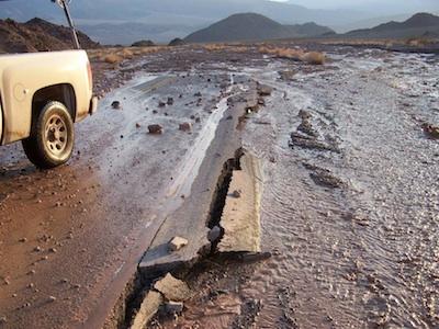
Heading to Death Valley National Park any time soon? If so, and you're planning to explore some of the more remote areas of the park, you should know that a good handful of roads have been washed away by unusually heavy (for Death Valley) July rains.
During July the park received three-quarters of an inch of rain, a monthly amount that hasn't been recorded in Death Valley since 1954, according to the Death Valley Natural History Association.
"The July storms brought major damage to many of the park's roads as well as taking out two power poles that left everyone sweating with no power in Cow Creek for days. Flash flooding has forced the closure of several Death Valley National Park roads," the association said in its August newsletter.
Here's a short video clip captured on July 29 (refresh your screen if it doesn't appear):
According to the association, the following roads are closed and will remain closed until repairs can be made:
* Badwater Road - south of Badwater Basin to the south entrance on Highway 178 near Shoshone, CA is closed. The Badwater Road from Highway 190 at Furnace Creek to Badwater Basin is open, and visitors can access the scenic view points along that 17 mile section of road.
* Big Pine/Death Valley Road - maintained by Inyo County
* Emigrant Canyon Road
* Panamint Valley Road - maintained by Inyo County
* Harry Wade Road
* Mustard Canyon Road
* Wildrose Road West Side Road
"Due to the number of roads needing to be cleared, and some of the road damage being quite serious (Badwater Road took a significant hit from the July 18th storm. Large chunks of the road are missing and debris piles have washed over the pavement for more than 20 miles) some of these major roads may take up to four weeks to get open," the association noted. "It may take longer to get to some of the other backcountry roads. Know before you go! Be sure you check conditions anytime you plan to travel within the park."
For the latest updates, check the park's Morning Report, which can be found on Death Valley National Park's homepage.


Add comment