
Editor's note: Being situated on the coast of Maine, Acadia National Park down through the years has been the final resting place for a number of ships. In the following story, Rebecca Cole-Will, the cultural resources program manager at Acadia, takes a look at a recent excavation of a wreck. The article appeared first in Friends of Acadia Journal. It is reprinted here with permission.
Acadia National Park is surrounded by water and much of its history and resources relate to its maritime location. It should be no surprise, then, that there are many shipwrecks in the waters around the park.
When maritime archeologist Franklin Price began research to document historic shipwrecks in the area, he spent a lot of time listening to fishermen, who, after all, know these waters better than anyone. Price grew up in Bernard and worked at lobster fishing for a time. He studied history as an undergraduate and then received his Master of Arts degree in maritime studies at East Carolina University.
Price's research has taken him to exotic and famous locales. He worked on the project to document Blackbeard's flagship, Queen Anne's Revenge, off the North Carolina coast. He spent time in Cyprus, studying an ancient Greek vessel and assisted on documenting Vasa, a 1628 Swedish warship. Currently, Price is a senior archaeologist with the State of Florida, where he coordinates diving operations and manages the state's Underwater Archaeological Preserve program.
But he is drawn back to Mount Desert Island, and tries to get home when possible. From his interviews with local fishermen, Price heard about historic wreck locations. From there, he combed old newspaper accounts of wrecks and bad storms. These provide information about when and possibly where wrecks occurred. Insurance claims and maritime records often document the size of a wrecked vessel and particulars of its cargo, or other circumstances of the event.
He eventually assembled a database of nearly 150 known wrecks in the waters surrounding MDI, from Penobscot to Frenchman Bays, reporting on the project with support from an L.L. Bean Acadia Research Fellowship through the SERC Institute and NPS.
One wreck in the Seal Cove area intrigued him. He recalled seeing it as a kid, and when he revisited it during this project it was still there. The wreck is remarkably preserved, lying up in the cove against the bank, where it is exposed at low water and protected from severe storms that would disarticulate the wooden skeleton.
Says Price, 'Recording vessels like this one is important because each represents a stage in wooden boat building technology. Wood was the material of choice in vessel construction for millennia, but now this has been eclipsed by fiberglass and steel. It is important to get all of the information we can from these old vessels while there is still enough left of them to study. This is especially important in the inter-tidal zone where exposure to air and ice slowly degrades the wooden structure.'

The field work led to this sketch of the shipwreck in Seal Cove. NPS image.
Price proposed the idea of a field school to document the site. Acadia National Park doesn't own the property but holds a conservation easement on it, where its jurisdiction extends to the low water mark. (The National Park Service does not manage shipwrecks or other resources beyond the intertidal zone, but does work with partners'the state, other federal agencies, landowners, and land conservation organizations' to protect and steward them.)
As an archaeologist and specialist in cultural resources at Acadia, I worked with Price, in partnership with the Town of Tremont and landowners, to develop the project with two primary goals. We wanted to reach out to interested local residents, park staff, students, and partner organizations to offer a hands-on learning experience to document an underwater archeological resource. And I was interested in building capacity at the park to handle this sort of project in the future.
Resources like this wreck are dotted all around the island and could be uncovered in the park as a result of storms. We might develop a local 'swat' team with some training to document wrecks after unexpected exposures.
This scenario has played out at other coastal national parks. At Cape Cod National Seashore, for example, storms frequently rework and erode whole stretches of the vulnerable sand beaches. There, wrecks are sometimes exposed for no more than one tide cycle and park staff must respond quickly to document and protect them.
Partial funding was secured from the Submerged Resources Center of the National Park Service and from the nonprofit Institute of Maritime History. Price enlisted Charles Bowdoin, a graduate student from his alma mater, to assist with project management.
We put out a call for participants''No experience required!'' and many community members joined us, including Friends of Acadia volunteers, Muriel Trask Davisson, a member of the Tremont Historical Society Board of Directors, and Otter Creek resident Karen Zimmerman, who came out for a day and wrote a blog about her experience (at www.fromthecreek.com).
Park staff participated as well, including Youth in Parks summer seasonals Kate Pontbriand and Clare Anderson and staff from the Resource Management and Resource Protection divisions. In all, 20 people were involved in various capacities'drawing, measuring, photographing, or taking notes.
We had to work with the tide. The site is only exposed for about three hours around low tide. Once it begins to turn, it takes only a few minutes before water rushes into the cove and the site is underwater. Price and Bowdoin prepared the site for mapping by running a datum line along the keel from stem to stern, or what was left of them. The goals were to map the site using tape and compass. While this may seem very low-tech in these days of laser scanning technology, remote sensing, satellite imagery, etc., it is tried and true.
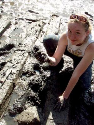
High schooler Kate Pontbriand got a valuable introduction to archaeology working on the shipwreck. NPS photo.
Archeologists in underwater or remote locations cannot always rely on technology. They are often left with a pencil, tape, and graph paper to produce a scale map of a site.
Teams of two or three worked together to measure and map the structural components of the vessel. We learned about how wooden vessels were put together'this one has a hewn timber keel, frames (the ribs), and trunnels (literally 'tree nails,' or wooden pegs) and iron spike fasteners. We mapped each of these features, using basic geometry to plot points on waterproof mylar.
Gradually, a scale map of the wreck emerged. On the last day, we literally played in the muck. I learned that underwater archeologists do not excavate sites the way I was taught as a traditional terrestrial archeologist. Trowels do not work in the thick, mucky sediment clinging to the wreck.
To expose the keel, we dug it out with our hands, feeling carefully for its shape. Afterward, participants agreed that it was a great experience. Local high school student Kate Pontbriand is interested in pursuing archaeology as a career, and noted, 'From drawing the sketch of the ship to digging around in the mud measuring the planks of the ship, everything interested me! I think the most memorable thing about this was being able to apply concepts I learned in my math classes at school to actual work. We triangulated pieces of wood from the base line we had set up in order to get accurate drawings of the ship. You sit in these math classes and always think 'When will I ever use this!?!' Real-world applications are rare and being able to have this experience was priceless.'
'Documenting shipwrecks in the Town of Tremont is important for the Tremont Historical Society, because they are part of Tremont's history,' said Muriel Trask Davisson. 'It was a great learning experience to participate and see how marine archeology is done.'
Bowdoin will give a presentation about the field school at the Society for Historical Archaeology's annual meeting in January 2012, and Bowdoin and Price will continue research to learn about the wreck.
Price observes, 'This particular vessel will be very difficult to identify. At the moment there are a couple of candidates that wrecked in Seal Cove in the late 1800s, both wooden schooners. Rinaldo wrecked in 1876 and Levant wrecked in 1883. Zach Whalen, a recent COA graduate, shared his research on them with the project. I fear that Rinaldo is too small to be this vessel, and I doubt we will be able to know conclusively if Levant was or not. Further research into the vessel's construction techniques will need to be done. Dendrochronology (counting tree rings) might also provide answers, but it is not part of the current project. Perhaps in the future we will learn more about this wreck.'
Rebecca Cole-Will is the cultural resources program manager at Acadia National Park, and an archaeologist specializing in pre-European-contact archaeology of New England and the Arctic.


Comments
This is a great article by one of the great cultural resource managers in the NPS, not only at Acadia, but country-wide. I can't wait to get back up to Acadia for the next NCHC Partners in the Parks project in August, when we will have honors students from many different colleges and universities camping, working, and learning from Rebecca and so many other excellent Park Service specialists. Bill Atwill, UNCW