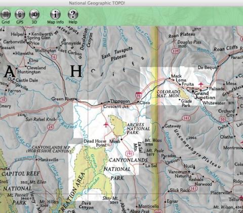
One CD-Rom that works with either Mac or PC. Powerful mapping software that let's you zoom in and out, pan right or left, and take a bird's eye 3-D view of the lay of the land. And the ability to load the map onto more than a few GPS units.
Has National Geographic hit upon something with its Trails Illustrated Explorer series?
My past experiences with National Geo mapping software were unremarkable, so much so that the disks are collecting dust somewhere in my office. I feared a similar experience when I slid the Moab edition (MRSP $24.95) of the Trails Illustrated Explorer series into my Mac. While it booted up quickly, the navigation was herky-jerky and generally disappointing.
Then I took National Geo's advise to make a copy of the program on my computer's hard-drive. That was the solution, and I soon found myself zooming in and out of not only Arches National Park, but also Canyonlands National Park and the nearby Colorado National Monument just the other side of the Utah-Colorado border.
The maps are the same as the paper ones you can buy off the shelf in your neighborhood REI, EMS, or family-brand backpacking store. (Although, unlike my 1994 version of the Canyonlands Trails Illustrated map, this software includes the Horseshoe Canyon unit) Same topo relief, same trails, same mileage indicators. Unlike the paper versions, though, this software lets you establish waypoints and routes, add notations in a separate box, add text labels right on the map and even add photos in a note box, print a specific area for field use, and even download a section onto GPS units made by Garmin, Magellan, and Eagle/Lowrance.
You can even create a specific route with waypoints and text labels, save it in a file, and email it off to a friend who also has the Trails Illustrated software to decipher this information. And if your friend has explored one of these parks and marked up their own software with waypoints and notes, they can email that to you and you can merge these two documents to overlay the two data sets for review and comparison.
The software also contains a drop-down trails directory that provides information on foot trails and Jeep trails. The information lists in which section of the park (for instance, in Canyonlands it breaks out the Island in the Sky, Needles, and Maze districts) the trail can be found, name of the trail, mileage, and short description. Zoom in close enough to one of the parks and you'll find trails listed by numbers that correspond to the master trails chart you can drop down. Slide your cursor over the number and a small dialog box opens with a brief trail description. There's also a link to the master trail chart, but this proved a bit buggy for my Mac, alternating between working just fine and crashing the program.
There's a button that allows you to toggle back and forth between laying down, or removing, grids from the map, and, of course, there are GPS coordinates and elevation data specific to wherever your cursor finds itself on the map. You can even arrange the "preferences" to track distances in kilometers, rather than miles, and elevation in meters above mean sea level vs. feet above mean sea level.
The software also has the ability to "Find" a place or trail by name, though the tiny yellow pinpoint that highlights the place on the map is a bit too tiny for my liking. Rather than the location jumping out at you, you have to search a little bit.
There's an interesting "Map Info" button. I say "interesting" because the instruction manual said this would lead to information on the parks covered by this software. I figured clicking the button would open up a page of information from the software itself. Instead it redirected me to a National Geo website with the information. The instructions claimed the software contained a PDF of that information, but it wasn't readily apparent.
That slight aside (and it's likely just operator error), this product far exceeded my past experiences with National Geo mapping software. Now all I have to do is print out the entire 58-page user's manual so I can see if I missed anything else...
Other parks covered by this Explorer series include Yosemite, Sequoia, and Kings Canyon, which are contained in the Sierra Nevada edition.


Add comment