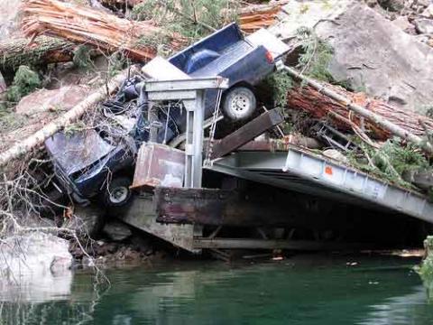
A large debris avalanche has covered an "administrative road" at North Cascades National Park Complex, and some visitor access will be affected for several months. Hikers and boaters intending to portage between Diablo Lake and Ross Lake need to take notice.
According to information from the park,
Boaters and paddlers on Diablo Lake and hikers on the Diablo Lake Trail are advised that a debris avalanche occurred at the head of Diablo Lake, rendering unusable a local access road that connects Diablo Lake with Ross Lake.
The road affected is the Ross Dam Haul Road, which is described by the park as:
an important administrative road that does not connect to any public road, but provides: Seattle City Light, operator of three hydroelectric dams within the park, with access from Diablo Lake to the Ross Powerhouse and the top of Ross Dam; Ross Lake Resort, a park concession operator of floating cabins on Ross Lake, with transportation service for their guests to and from Diablo Lake; and, paddlers with portage between Diablo Lake and Ross Lake.
The North Cascades website includes several maps of the park which will help you identify the areas involved.
“We are working with Seattle City Light to provide paddlers, hikers, and Ross Lake Resort guests with access between the two lakes as soon as it is safe to do so,” explained North Cascades National Park Complex Superintendent Chip Jenkins. “In the meantime, for your safety, please avoid the area near the slide and explore some of the many other wonderful areas in the park available to you this spring.”
The size of the slide make it unfeasible to remove, thus Seattle City Light plans to develop a new barge landing upstream of the slide to provide access to Ross Powerhouse. A new dock and trail downstream of the slide are also planned to provide Seattle City Light with access to the top of Ross Dam, support Ross Lake Resort and National Park Service operations, and reestablish portage between Diablo Lake and Ross Lake for paddlers.
In the meantime, heed that advice to stay clear of the area. The park notes,
The area remains unstable and dangerous. Several large rocks could still fall and double the volume of material, making recovery even more difficult and time-consuming. A contractor has been hired to evaluate and stabilize the cliff above the slide.
No person should be above, below, or on the sides of the debris avalanche. Boaters and paddlers should not approach the area. A floating marker will be installed, but until then, boaters and paddlers are asked to turn around when the Ross Dam Haul Road tunnel becomes visible. Gates will be installed at the Ross Dam Haul Road tunnel and on the suspension bridge over the gorge to prevent hikers from entering the area.
The slide is about 200 feet wide at its toe and contains approximately 56,000 cubic meters of material. It destroyed Seattle City Light’s barge dock, Ross Lake Resort’s truck, and the park's canoe and kayak landing.
The most immediate impact for visitors will be to boaters who want to portage to Ross Lake. According to the park,
The lower end of the Ross Haul Road is closed and impassable to boaters attempting to portage to Ross Lake. The slide obliterated the end of the road, and did serious damage to two boat docks, as well as damaging the canoe take-out area. The slide area is not stable—do not attempt to enter the closed area.
The suspension bridge over Diablo Arm is also closed. The Ross Dam Trail (milepost 134 off State Route 20) is unaffected and could be used as a portage route to Ross Lake if need be, although keep in mind that this is a rocky, switchbacking trail that descends one mile and 900 feet to reach the lake.
If you're planning a stay at Ross Lake Resort this summer, you don't have to change your plans. I spoke to Tom Barnett, the owner of the resort, and he says that although some adjustments will need to be made, visitors will still be able to reach the resort via the ferry service, and they plan to open as scheduled for the summer season.
The park also has some advice for hikers about trails in the area which are affected by the situation:
Access to Ross Dam Trail, Happy-Panther Trail, and East Bank Trail all remain possible from the Ross Dam Trailhead along the North Cascades Highway (State Route 20) at milepost 134.
Access to the Diablo Lake Trail remains possible from the trailhead at the end of the Diablo Dam Road which leaves the North Cascades Highway (State Route 20) at milepost 127.5.
Through hikes along the Diablo Lake Trail between this trailhead and the Ross Dam Trailhead are not currently possible due to the debris avalanche.
Perhaps you're wondering how a "debris avalanche" differs from a landslide. According to the U. S. Geological Survey,
Debris avalanches are moving masses of rock, soil and snow that occur when the flank of a mountain or volcano collapses and slides downslope. As the moving debris rushes down a volcano and into river valleys, it incorporates water, snow, trees, bridges, buildings, and anything else in the way. Debris avalanches may travel several kilometers before coming to rest, or they may transform into more water-rich lahars, which travel many tens of kilometers downstream.
Information from Michigan Tech University notes that "a debris avalanche is formed when an unstable slope collapses and debris is transported away from the slope; Landslide is a general term for mass movement. It implies a gradual movement rather than the more sudden movement of an avalanche."
No matter what term you apply to the situation, the accompanying photo makes it clear the best news from this event is that it occurred during a time of minimal visitor activity.


Add comment