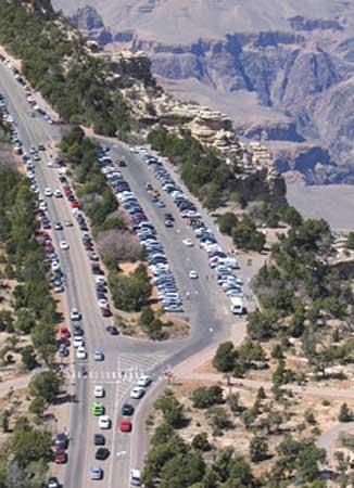
The majority of visitors to Grand Canyon National Park arrive by vehicle through the south entrance, and their first glimpse of the canyon itself usually comes at Mather Point. It's a great overlook with fine views, but in recent years, what should be a memorable experience was often marred by traffic snarls and the difficulty in finding a parking place. It wasn't a great way to start your visit to one of the world's great wonders.
The NPS has been working hard to correct those distractions, and much of that effort is guided by the "South Rim Visitor Transportation Plan." That plan was developed by the park and the U.S. Forest Service's Kaibab National Forest, which manages the land adjoining the park.
The goals of the plan include dealing with the parking problems and providing a logical flow of both vehicles and pedestrians that will lead visitors to Mather Point, the visitor center and shuttle bus staging areas. Separate parking areas for tour bus parking will separate that traffic from private vehicles, and visitors will be able to access all of the park's shuttle bus routes from a single, centralized shuttle bus staging area. That "bus stop" will be convenient to new parking areas and the visitor center.
Perhaps best of all, the prime attraction—the view of the canyon at Mather Point—will be free of the noise and distractions of a seemingly endless parade of tour busses, cars, RVs and other traffic that crawled past Mather Point, only a few steps from the overlook.
So, how's it going?
Phase I of the project was completed late last year, and included construction of 600 new visitor parking spaces and 40 new commercial tour vehicle parking spaces near the Visitor Center. The South Entrance Road was realigned to the south of the Visitor Center, portions of the old roadway were removed, and the old Mather Point parking area was removed. Areas impacted by that work were rehabilitated.
Phase II of the work is set to begin in March—if the weather cooperates—and be finished by December of this year, so if you visit the area this spring and summer, you'll likely encounter some construction in the Mather Point vicinity. Disruptions to your visit should be minor, and the end of work at that location is in sight.
According to the park,
Throughout the project, the Visitor Center, Grand Canyon Books and More, restrooms and new parking areas will remain open and easily accessible to visitors.
During construction, it will be necessary to close off access to portions of the canyon rim in the Mather Point area. However, 350 feet of rim in this area will remain open at all times and pedestrian detours will be clearly marked directing visitors from the Visitor Center to Mather Point and guiding Rim Trail hikers through the construction zone.
The park’s free, accessible shuttle buses will serve the Visitor Center complex throughout Phase II construction and will continue to serve the shuttle bus stop on the west end of the complex for the time being.
What will future visitors find when work is completed late this year?
This phase of the work includes a new shuttle bus staging area, new restrooms at the north end of the new commercial tour vehicle parking lot, and three new picnic areas. The existing shuttle bus stop west of the visitor center will be converted to picnic pavilions and an informal amphitheater will be constructed on the rim east of Mather Point overlook.
There's been a lot of wear and tear on the landscape in this area over the decades, so the Mather Point overlook will be rehabilitated. That work includes reconstruction of the stairs, adding an accessible pathway to the overlook, and installing new railing along the entire rim area of Mather Point. All of the remaining old roadway and parking lot at Mather Point will be removed and the area will be revegetated.
Is this it for changes in the area? For the short-term, yes.
Within the next few years, the NPS also plans on expanding interpretive services at the Visitor Center. These changes will improve visitor orientation and wayfinding and provide a theater, bike rental facility and limited food items within the Visitor Center complex.
There's been plenty of discussion on the Traveler about the pros and cons of entrance fees, but here's one example of where some of that money goes. During construction, updates on the project will be available on the park’s web site.


Comments
And those of you in the parks without entrance fees, who desperately need improvements to protect resources and serve the public - well. just stand their with your tin cup out and hope for the best. Because the NPS does not make decisions based on the greater good, it makes decisions that favor the rich parks.