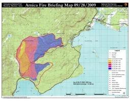
A burst of wintry weather Wednesday greatly dampened the Arnica Fire in Yellowstone National Park, where fire crews were demobilizing while others worked to reopen a section of the Grand Loop Road that had been closed by the fire.
Rain started falling on the park around 6 a.m. Wednesday, and soon turned to snow, park officials reported.
"With the rapid change in weather in Yellowstone National Park to winter-like conditions, the Arnica Fire operations will be considerably downsized today. Fire fighters will be pulling all sprinkler systems and water supply equipment and moving back to Mammoth and the North Entrance," read a park release. "As conditions change, the National Park Service is making every effort to safely and rapidly reopen the road between Lake and West Thumb. This will entail removing the fire-damaged trees that pose a threat on and along the road to travelers. Heavy equipment will be used to rapidly remove these hazardous trees."
The fire, which was reported September 23 on the west side of Yellowstone Lake in the vicinity of Arnica Creek, was estimated by fire bosses to cover 10,700 acres. While the rain and snow were expected to douse the flames, some heavy fuels could smolder longer, they said.
At the height of the fire, the Park Service had 230 personnel protecting housing, lodges and historic park structures in the Lake Village and Bridge Bay areas.


Comments
I happened to be traveling from Yellowstone to Grand Teton on Sept. 23, the day the Arnica fire was reported. On the morning of the 24th, smoke from the Bearpaw Bay fire was staying fairly low as it drifted southward, obscuring the feet of the Tetons but not the summits. By that afternoon, a much bigger, higher smoke cloud came out of the north--from Arnica, I presume--and really created some sunset "pyrotechnics." If anyone's interested, the last half-dozen of the trip photos I recently posted (http://www.flickr.com/photos/doublefinch/sets/72157622501999620/detail/)show this sequence. However, like many of the above, I felt sorry for visitors who found views obscured and/or breathing difficult, especially the next morning when Jackson Hole looked like L.A. on a bad air day.
Romotrekker, I am green with envy !!!
Great Pictures!!!!