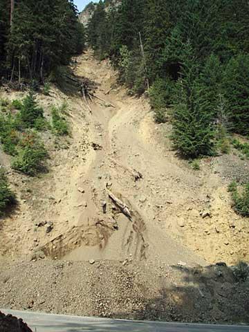
Roads in two NPS areas that were closed recently due to rockslides have reopened in time for the coming weekend—and the approaching end of the peak summer season. As previously reported in the Traveler, the routes involved are an eight-mile section of Little River Roadin Great Smoky Mountains National Park and the Hurricane Ridge Road in Olympic National Park.
The eight-mile section of Little River Road in Great Smoky Mountains National Park that was closed on Friday because of a rock slide reopened Tuesday evening.
On the opposite side of the country, at Olympic National Park in Washington State, the 17-mile Hurricane Ridge Road will reopen Thursday afternoon—but for daylight use only—as park crews continue to deal with an ongoing rockfall.
The popular road was closed last Sunday as a precaution due to a "slow but continuous rockfall onto the road." According to a statement from the park Thursday morning, the road:
will reopen today for daylight use only, as long as conditions remain safe. Visitors are urged to use extra caution, and to be prepared for flaggers and a short section of unpaved roadway near the rockfall site.
The road will open at 2:00 p.m. today and close at 9:00 p.m. this evening. The gate at Heart o’the Hills entrance station, five miles above the Olympic National Park Visitor Center, will be locked overnight, beginning at 9:00 p.m.
Crews will closely monitor the rockfall area and if conditions continue to allow, the road will open daily at 8:00 a.m. and close at 9:00 p.m. Flaggers and a rockfall monitor will be stationed near the rockslide and will control traffic through the area.
“Our crews have made significant improvements to the berm, and have shifted the travel lanes to allow safe passage through the area,” said Sue McGill, Olympic National Park Deputy Superintendent. “The rockfall site is still active, however and we will continue to closely monitor the area; further closures may be necessary.”
“Visitor and employee safety remain our highest priority however, and we will keep the road open as long as it is safe to do so,” emphasized McGill.
The existing rock berm at the base of at the rock fall chute was enlarged and improved by the park’s road crew and is now 10 feet high. Concrete barriers have been placed at the base of the berm. In addition, the travel lanes have been slightly shifted onto an adjacent pullout; visitors should use caution on this area of the road, as these temporary travel lanes are unpaved.
Park staff and a Federal Highway Administration engineering geologist visited the site again this morning and observed several rockfalls. The newly improved berm prevented any rocks from reaching the road.
Members of the park maintenance staff flew over the site yesterday and were able to better observe the summit and upper slope of the rockfall chute. Based on their observations, the short-term improvements made today will allow the road to open on a conditional basis, while additional monitoring and long term plans can be completed.
The rockfall originates on a steep slope high above the road and follows a winter avalanche chute about nine miles south of Port Angeles and four miles above the Heart o’the Hills entrance station. A slow but continuous stream of falling rocks and gravel began on Saturday, August 15 and continued the following day, when the road was closed to all traffic. Rocks have continued to fall since then, though at a reduced rate.
If you're planning a visit to the park in the near future, you can find updated information on the park's website, or you can call the Olympic National Park Visitor Center during normal operating hours at 360-565-3130.
A recorded Road and Weather Hotline is also updated throughout the day; call 360-565-3131 for that information.


Add comment